Ichitana Station 市棚駅 | |||||||||||
|---|---|---|---|---|---|---|---|---|---|---|---|
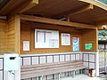
 Ichitana Station in 2007 | |||||||||||
| General information | |||||||||||
| Location | Kitagawamachi Kawachimyo, Nobeoka-shi, Miyazaki-ken 889-0101 Japan | ||||||||||
| Coordinates | 32°43′42″N 131°42′37″E / 32.72833°N 131.71028°E | ||||||||||
| Operated by |
| ||||||||||
| Line(s) | ■ Nippō Main Line | ||||||||||
| Distance | 238.5 km from Kokura | ||||||||||
| Platforms | 1 side + 1 island platforms | ||||||||||
| Tracks | 3 + 1 siding | ||||||||||
| Construction | |||||||||||
| Structure type | At grade | ||||||||||
| Accessible | No - island platform accessed by footbridge | ||||||||||
| Other information | |||||||||||
| Status | Unstaffed | ||||||||||
| Website | Official website | ||||||||||
| History | |||||||||||
| Opened | 1 July 1923 | ||||||||||
| Passengers | |||||||||||
| FY2015 | 13 daily | ||||||||||
| Services | |||||||||||
| |||||||||||
| Location | |||||||||||
 Ichitana Station Location within Miyazaki Prefecture  Ichitana Station Ichitana Station (Japan) | |||||||||||
|
| |||||||||||
Ichitana Station (市棚駅, Ichitana-eki) is a passenger railway station in the city of Nobeoka, Miyazaki, Japan. It is operated by of JR Kyushu. [1] [2]It is the easternmost and northernmost station in Miyazaki Prefecture; between this station and Sotaro Station, is the prefectural border between Oita Prefecture and Miyazaki Prefecture.
Lines
The station is served by the Nippō Main Line and is located 238.5 km from the starting point of the line at Kokura. [3] Only local trains stop at this station.
Layout
The station consists of a side platform and an island platform serving three tracks at grade with a siding branching off track 3, all set in an open area of rural farmland. The station is not staffed and is no station building but a public toilet has been set up at the station entrance which also has a passenger shelter on the other side. Access to the island platform is by means of a footbridge. A bike shed is provided at the station forecourt. [2] [3]
Platforms
| 1 | ■ ■ Nippō Main Line | for Saiki |
| 2 | ■ ■ Nippō Main Line | for passage of express and freight trains |
| 3 | ■ ■ Nippō Main Line | for Nobeoka |
-
 Passenger shelter. This is on the other side of the toilet building seen in the top image.
 -
 A view of the tracks at the station, looking south. The siding can be seen branching off to the left.


History
In 1913, the Miyazaki Prefectural Railway (宮崎県営鉄道) had opened a line from Miyazaki northwards to Hirose (now closed). After the Miyazaki Prefectural Railway was nationalized on 21 September 1917, Japanese Government Railways (JGR) undertook the subsequent extension of the track which it designated as the Miyazaki Main Line. Expanding north in phases, the track reached Ichitana which was established as the northern terminus on 1 July 1923. At the same time, JGR had been expanding its Hoshū Line south from Kokura down the east coast of Kyushu, reaching its southern terminus of Shigeoka just 9 km north of Ichitana by March 1922. The link up between the two lines was achieved on 15 December 1923, through-traffic was thus established from Kokura through Ichitana to Miyakonojō. The entire stretch of track was then renamed the Nippō Main Line. Freight operations and baggage handling were abolished in 1972 and the station became unmanned. With the privatization of Japanese National Railways (JNR), the successor of JGR, on 1 April 1987, the station came under the control of JR Kyushu. [4] [5] [6]
Passenger statistics
In fiscal 2016, the station was used by an average of 13 passengers (boarding only) per day. [7]
Surrounding area
- Japan National Route 10
- Kagamiyama Observatory
- Kagamiyama Paragliding Takeoff Field
See also
References
- ^ "JR Kyushu Route Map" (PDF). JR Kyushu. Retrieved 23 February 2018.
- ^ a b "市棚" [Ichitana]. hacchi-no-he.net. Retrieved 20 June 2018.
- ^ a b Kawashima, Ryōzō (2013). 図説: 日本の鉄道 四国・九州ライン 全線・全駅・全配線・第6巻 熊本 大分 エリア [Japan Railways Illustrated. Shikoku and Kyushu. All lines, all stations, all track layouts. Volume 6 Kumamoto Ōita Area] (in Japanese). Kodansha. pp. 49, 84. ISBN 9784062951654.
- ^ Ishino, Tetsu; et al., eds. (1998). 停車場変遷大事典 国鉄・JR編 [Station Transition Directory – JNR/JR] (in Japanese). Vol. I. Tokyo: JTB Corporation. pp. 228–9. ISBN 4-533-02980-9.
- ^ Ishino, Tetsu; et al., eds. (1998). 停車場変遷大事典 国鉄・JR編 [Station Transition Directory – JNR/JR] (in Japanese). Vol. II. Tokyo: JTB Corporation. p. 756. ISBN 4-533-02980-9.
- ^ Imao, Keisuke (2009). 日本鉄道旅行地図帳 12号 九州 沖縄―全線・全駅・全廃線 [Japan Rail Travel Atlas No. 12 Kyushu Okinawa - all lines, all stations and disused lines] (in Japanese). Mook. pp. 62–3. ISBN 9784107900302.
- ^ "宮崎県統計年鑑 鉄道輸送実績(1日平均)" [Miyazaki Prefecture Statistics Yearbook Railway Transportation Record (daily average)]. Miyazaki Prefectural Government website. Archived from the original on 7 May 2018. Retrieved 6 May 2018. See the table for 平成28年度 [fiscal 2016].
External links
- Ichitana (JR Kyushu)(in Japanese)
|
| This Miyazaki Prefecture railroad station-related article is a stub. You can help Wikipedia by expanding it. |