| Hunewill Peak | |
|---|---|
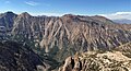
 Southeast aspect, from
The Incredible Hulk | |
| Highest point | |
| Elevation | 11,713 ft (3,570 m) [1] |
| Prominence | 753 ft (230 m) [2] |
| Parent peak | Eagle Peak (11,847 ft) [3] |
| Isolation | 2.39 mi (3.85 km) [3] |
| Coordinates | 38°09′32″N 119°26′36″W / 38.1588783°N 119.4434646°W [4] |
| Naming | |
| Etymology | N. B. Hunewill (1828–1908) |
| Geography | |
 Hunewill Peak Location in California  Hunewill Peak Hunewill Peak (the United States) | |
| Location | Mono County, California, U.S. |
| Parent range | Sierra Nevada |
| Topo map | USGS Buckeye Ridge |
| Geology | |
| Mountain type | Fault block |
| Climbing | |
| First ascent | 1946 |
| Easiest route | class 2 hiking [3] via Barney Lake |
Hunewill Peak is a mountain with a summit elevation of 11,713 feet (3,570 m) located in the Sierra Nevada mountain range, in Mono County of northern California, United States. [4] The summit is set in Hoover Wilderness on land managed by Humboldt–Toiyabe National Forest. The peak is situated approximately four miles west of Twin Lakes, 1.3 mile southwest of Victoria Peak, and 2.4 miles southwest of line parent Eagle Peak. Precipitation runoff from this mountain drains into tributaries of Robinson and Buckeye Creeks, which are within the Walker River drainage basin. Topographic relief is significant as the summit rises over 3,500 feet (1,100 meters) above Robinson Creek in approximately one mile (1.6 km).
History
Hunewill Peak is the toponym officially adopted in 1962 by the U.S. Board on Geographic Names to remember Napoleon Bonaparte "N. B." Hunewill (1828–1908), a pioneer who operated the Eagle Creek Lumber Mill in this area in the 1860s and supplied timber to build the mining town of Bodie. [4]
The first ascent of the summit was made in 1946 by Ken Crowley, R. Dickey Jr., Ken Hargreaves, and H. Watty. [1]
Climate
According to the Köppen climate classification system, Hunewill Peak is located in an alpine climate zone. [5] Most weather fronts originate in the Pacific Ocean, and travel east toward the Sierra Nevada mountains. As fronts approach, they are forced upward by the peaks ( orographic lift), causing moisture in the form of rain or snowfall to drop onto the range.
See also
Gallery
-
 Hunewill Peak (left), Victoria Peak (centered), Eagle Peak (right).
View looking north from The Incredible Hulk. -
 Aerial view of north aspect of Hunewill Peak (centered).
Buckeye Creek Canyon in lower left.


References
- ^ a b R.J. Secor (2009), The High Sierra: Peaks, Passes, Trails, Mountaineers Books, ISBN 9781594857386, p. 476
- ^ "Hunewill Peak, California". Peakbagger.com. Retrieved 2022-04-27.
- ^ a b c "Hunewill Peak - 11,713' WA". listsofjohn.com. Retrieved 2022-04-27.
- ^ a b c "Hunewill Peak". Geographic Names Information System. United States Geological Survey, United States Department of the Interior. Retrieved 2022-04-27.
- ^ Peel, M. C.; Finlayson, B. L.; McMahon, T. A. (2007). "Updated world map of the Köppen−Geiger climate classification". Hydrol. Earth Syst. Sci. 11. ISSN 1027-5606.
External links
- Weather forecast: Hunewill Peak
- N. B. Hunewill photo
- Hunewill Peak pronunciation