-
 Hopewell Union Church
 -
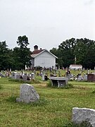 Hopewell Union Church Cemetery
Hopewell
Hopewell Furnace | |
|---|---|
 Hopewell General Store | |
 Hopewell Map showing Hopewell in Missouri | |
| Coordinates: 37°53′15″N 90°42′10″W / 37.88750°N 90.70278°W | |
| Country | United States |
| State | Missouri |
| County | Washington |
| Platted | 1858 |
Hopewell is an unincorporated community in eastern Washington County, Missouri, United States. [1] The community lies on Hopewell Creek, south of Summit and Missouri Route 8. [2]
History
Hopewell was originally called "Hopewell Furnace", and under the latter name was platted in 1858, and named after a nearby blast furnace of the same name. [3] A post office called Hopewell Furnace was established in 1855, the name was changed to Hopewell in 1886, and the post office closed in 1978. [4]
Gallery


References
- ^ U.S. Geological Survey Geographic Names Information System: Hopewell, Washington County, Missouri
- ^ Mineral Point, Missouri, 7.5 Minute Topographic Quadrangle, USGS, 1958
- ^ "Washington County Place Names, 1928–1945". The State Historical Society of Missouri. Archived from the original on June 24, 2016. Retrieved December 30, 2016.
- ^ "Post Offices". Jim Forte Postal History. Retrieved December 30, 2016.
Municipalities and communities of
Washington County, Missouri, United States | ||
|---|---|---|
| Cities |  | |
| Villages | ||
| Townships | ||
|
Unincorporated communities |
| |
| Ghost towns | ||
| Footnotes | ‡This populated place also has portions in an adjacent county or counties | |
|
| This Washington County, Missouri state location article is a stub. You can help Wikipedia by expanding it. |