Hilo is a moku or district on the Big Island of Hawaiʻi in the State of Hawaii, U.S.A. In the current system of administration of Hawaiʻi County, the moku of Hilo is divided into North Hilo District (Hilo ‘Akau) and South Hilo District (Hilo Hema).
Hilo is located on the eastern, windward side of the island, enjoying abundance of rainfall, and therefore includes the island's most populated town, also called Hilo. [1]

North Hilo District
In the District of North Hilo, there are, along Hawaii State Highway 19 from north to south, the following unincorporated towns and localities:
- ʻŌʻōkala
- Laupāhoehoe and the Train Museum [2]
- Ninole
and others. Inland, along State Highway 200, are:
- Mauna Kea mountain road and Puu Huluhulu
and others.
South Hilo District
In the District of South Hilo, there are, along State Highway 19, the following unincorporated towns and localities:
- Honomu and the Akaka Falls
- Pepeekeo
- Wainaku
- Hilo Bay, the Wailuku River and the Rainbow Falls
- Hilo downtown: Pacific Tsunami Museum, Hawaii Community Correctional Center, etc.
Along State Highway 11, are:
- Hilo International Airport
- King Kuhio Shopping Center [3]
- Pana'ewa Rainforest Zoo
and others. Along State Highway 200 and its extension, are:
- Kaumana
- University of Hawaii at Hilo
- Puainako Shopping Center [4]
and others.
Gallery
-
 Rainbow Falls, Hawaii
 -
 Kamehameha Statue in Hilo
 -
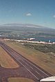 Hilo International Airport, with Mauna Kea in the back
 -
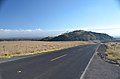 Puu Huluhulu as seen from the Mauna Kea road


.jpg)
References
- ^ James A. Bier, Cartographer, Map of Hawai'i, the Big Island, Eighth Edition (University of Hawai'i Press)
- ^ Laupāhoehoe Train Museum
- ^ King Kuhio Shopping Center
- ^ Puanako Center
External links
