Hilltown, Virginia | |
|---|---|
 Hilltown  Hilltown | |
| Coordinates: 36°43′45″N 80°58′56″W / 36.7293°N 80.9822°W | |
| Country | United States |
| State | Virginia |
| Counties |
Grayson Carroll |
| Area | |
| • Total | 0.56 sq mi (1.44 km2) |
| • Land | 0.56 sq mi (1.44 km2) |
| • Water | 0.0 sq mi (0.0 km2) |
| Population | 216 |
| Time zone | UTC-5 ( Eastern (EST)) |
| • Summer ( DST) | UTC-4 (EDT) |
| ZIP Code | 24330 (
Fries) |
| Area code | 276 |
| FIPS code | 51-37380 |
| GNIS feature ID | 2807423 [3] |
Hilltown is an unincorporated community and census-designated place (CDP) in Grayson and Carroll counties, Virginia, United States. As of the 2020 census, it had a population of 216. [2]
The CDP is in eastern Grayson County and western Carroll County, along Virginia State Route 94. It is bordered to the west by Stevens Creek and to the south by Fries. Hilltown is 9 miles (14 km) northwest of Galax and 25 miles (40 km) south of Wytheville. The New River passes within one mile of Hilltown to the south and east.
References
- ^ "2020 U.S. Gazetteer Files – Virginia". United States Census Bureau. Retrieved October 22, 2021.
- ^ a b "Hilltown CDP, Virginia: 2020 DEC Redistricting Data (PL 94-171)". U.S. Census Bureau. Retrieved October 22, 2021.
- ^ "Hilltown Census Designated Place". Geographic Names Information System. United States Geological Survey, United States Department of the Interior.
Municipalities and communities of
Grayson County, Virginia, United States | ||
|---|---|---|
| Towns | 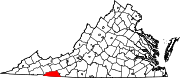 | |
| CDPs | ||
|
Other communities | ||
| Footnotes | ‡This populated place also has portions in an adjacent county or counties | |
Municipalities and communities of
Carroll County, Virginia, United States | ||
|---|---|---|
| Town | 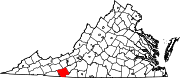 | |
| CDPs | ||
|
Unincorporated communities | ||
| Footnotes | ‡This populated place also has portions in an adjacent county or counties | |
|
| This Carroll County, Virginia state location article is a stub. You can help Wikipedia by expanding it. |
|
| This Grayson County, Virginia state location article is a stub. You can help Wikipedia by expanding it. |