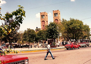
Hidalgo del Parral | |
|---|---|
 Parral city, seat of the municipality | |
 Municipality of Hidalgo del Parral in Chihuahua | |
| Coordinates: 26°56′N 105°40′W / 26.933°N 105.667°W | |
| Country | |
| State | Chihuahua |
| Municipal seat | Hidalgo del Parral |
| Area | |
| • Total | 1,751 km2 (676 sq mi) |
| Population (2010) | |
| • Total | 107,061 |
Hidalgo del Parral is one of the 67 municipalities of Chihuahua, in northern Mexico. The municipal seat lies at Hidalgo del Parral (Parral City). The municipality covers an area of 1,751 km2.
As of 2010, the municipality had a total population of 107,061, [1] up from 103,519 as of 2005. [2]
As of 2010, the city of Hidalgo del Parral had a population of 104,836. [1] Other than the city of Hidalgo del Parral, the municipality had 192 localities, none of which had a population over 1,000. [1]
Geography
Towns and villages
The municipality has 112 localities. The largest are:
| Name | Population (2005) |
|---|---|
| Hidalgo del Parral | 101,147 |
| Maclovio Herrera | 141 |
| El Cobeño | 123 |
| La Esmeralda | 113 |
| Minas Nuevas | 43 |
| Total Municipality | 103,519 |
References
- ^ a b c "Hidalgo del Parral". Catálogo de Localidades. Secretaría de Desarrollo Social (SEDESOL). Retrieved 23 April 2014.
- ^ "Hidalgo del Parral". Enciclopedia de los Municipios de México. Instituto Nacional para el Federalismo y el Desarrollo Municipal. Archived from the original on February 23, 2007. Retrieved October 13, 2008.

