Herten | |
|---|---|
Village | |
 The centre of Herten, with the church of St. Michaël | |
 Herten Location in the Netherlands  Herten Location in the province of Limburg in the Netherlands | |
| Coordinates: 51°11′N 5°58′E / 51.183°N 5.967°E | |
| Country | Netherlands |
| Province | Limburg |
| Municipality | Roermond |
| Area | |
| • Total | 1.11 km2 (0.43 sq mi) |
| Elevation | 22 m (72 ft) |
| Population (2021)
[1] | |
| • Total | 3,350 |
| • Density | 3,000/km2 (7,800/sq mi) |
| Time zone | UTC+1 ( CET) |
| • Summer ( DST) | UTC+2 ( CEST) |
| Postal code | 6049
[1] |
| Dialing code | 0475 |
Herten is a village in the southeastern Netherlands. It is located in the municipality of Roermond, Limburg.
History
The village was first mentioned in the middle of the 11th century as Hercena. The etymology is unknown. [3] Herten developed in the Middle Ages along the Maas. In 1716, it became part of the Austrian Upper Guelders. [4]
The Catholic St Michael Church was originally from the 13th century. In 1881, the tower collapsed and a new church was built in Gothic Revival style. The church was completely destroyed in 1945, and a new church was built between 1953 and 1954 and was designed by Hendrik Willem Valk. [4]
Herten was home to 153 people in 1840. [5] It was severely damaged during World War II. After the war, it became a commuter's village for Roermond. [4] Herten was a separate municipality until 1991, when it was merged with Roermond. [6] The municipality also covered the smaller villages of Merum and Ool. Even though Roermond and Herten have formed a single urban area, Herten is a separate village. [5]
Gallery
-
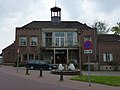 Former town hall

References
- ^ a b c "Kerncijfers wijken en buurten 2021". Central Bureau of Statistics. Retrieved 25 April 2022.
- ^ "Postcodetool for 6049AA". Actueel Hoogtebestand Nederland (in Dutch). Het Waterschapshuis. Retrieved 25 April 2022.
- ^ "Herten - (geografische naam)". Etymologiebank (in Dutch). Retrieved 25 April 2022.
- ^ a b c Sabine Broekhoven, & Ronald Stenvert (2003). Herten (in Dutch). Zwolle: Waanders. ISBN 90-400-9623-6. Retrieved 25 April 2022.
- ^ a b "Herten". Plaatsengids (in Dutch). Retrieved 25 April 2022.
- ^ Ad van der Meer and Onno Boonstra, "Repertorium van Nederlandse gemeenten", KNAW, 2006. "KNAW > Publicaties > Detailpagina". Archived from the original on 2007-02-20. Retrieved 2009-12-03.
|
| This Dutch Limburg location article is a stub. You can help Wikipedia by expanding it. |