Henryków | |
|---|---|
Village | |
 Cistercian monastery | |
 Henryków  Henryków | |
| Coordinates: 50°39′09″N 17°00′39″E / 50.65250°N 17.01083°E | |
| Country | |
| Voivodeship | Lower Silesian |
| County | Ząbkowice Śląskie |
| Gmina | Ziębice |
| First mentioned | 1222 |
| Population | 1,400 |
| Time zone | UTC+1 ( CET) |
| • Summer ( DST) | UTC+2 ( CEST) |
| Vehicle registration | DZA |
| Voivodeship roads |
|
Henryków [xɛnˈrɨkuf] is a village in the administrative district of Gmina Ziębice, within Ząbkowice Śląskie County, Lower Silesian Voivodeship, in south-western Poland. [1]
It lies approximately 7 kilometres (4 mi) north of Ziębice, 16 kilometres (10 mi) north-east of Ząbkowice Śląskie, and 53 kilometres (33 mi) south of the regional capital Wrocław.
The village contains the landmark Cistercian Monastery Complex. A Latin chronicle, the Book of Henryków, compiled at Henryków abbey in the 13th century contains the first known sentence written in the Polish language.
There is a train station in Henryków.
Gallery
-
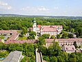 Aerial view of the Cistercian Monastery
 -
 Monument to the Book of Henryków
 -
 Brama Parkowa (Park Gate)
 -
 Train station


Surroundings
References
| Town and seat |  | |
|---|---|---|
| Villages | ||
| International | |
|---|---|
| National | |
|
| This Ząbkowice Śląskie County location article is a stub. You can help Wikipedia by expanding it. |