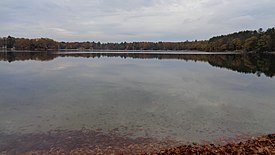
| Heart Lake | |
|---|---|
 View from E. Heart Lake Road access point | |
| Location | Otsego County, Michigan |
| Coordinates | 44°53′34″N 84°41′33″W / 44.89278°N 84.69250°W |
| Type | Kettle lake |
| Basin countries | United States |
| Surface area | 63 acres (0.3 km2) |
| Max. depth | 123 ft (37 m) |
| Surface elevation | 1,257 feet (383 m) [1] |
| Islands | none |
| Settlements | Otsego Lake Township |
Heart Lake, Michigan is located in Otsego County in northern Michigan, about nine miles (14 km) south of Gaylord, just west of Interstate 75.
Heart Lake is so named due to its irregular shape of a valentine heart.
Heart Lake comprises about 63 acres (0.3 km2), has a maximum depth of 123 feet (37 m). The lake is a classic example of a kettle lake, many of which dot the landscape in this area. The lake holds healthy populations of splake, rainbow trout, bass, northern pike, and perch, and is popular with area fishermen. While surrounded mostly by private residences, there is one public access point along East Heart Lake Road, which is maintained by the nearby Otsego Lake State Park. [2]
See also
External links
- "Michigan DNR map of Heart Lake" (PDF). (566 KiB)
- U.S. Geological Survey Geographic Names Information System: Heart Lake (Michigan)
References
Further reading
- Scott, I.D. (1921) Inland Lakes of Michigan Michigan Geological Society.
