| Hayton | |
|---|---|
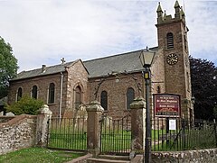
 Church of Mary Magdalene, Hayton | |
Location in the
City of Carlisle district,
Cumbria Location within
Cumbria | |
| Population | 2,222 (2011) |
| OS grid reference | NY507576 |
| Civil parish |
|
| District | |
| Shire county | |
| Region | |
| Country | England |
| Sovereign state | United Kingdom |
| Post town | BRAMPTON |
| Postcode district | CA8 |
| Dialling code | 01228 |
| Police | Cumbria |
| Fire | Cumbria |
| Ambulance | North West |
| UK Parliament | |
Hayton is a small village and civil parish in Cumbria, England, roughly 8 miles (13 km) east of Carlisle, and 10 miles (16 km) from the England/Scotland border. The population of the parish taken at the 2011 census was 2,222. [1]
The place name Hayton means hay farm and refers to the former farming in the area. There is a separate settlement named Hayton within Cumbria near Aspatria. St. Mary Magdalene Church was built in 1780. In the church are a number of memorials to the Graham family of Edmond Castle. Edmond Castle, a mile from the village, is thought to date from earlier than the 17th century. [2] [3] The nearby Toppin Castle farmhouse is a nineteenth-century imitation tower house.
Places of interest
- Edmond Castle
- Hayton Church of England primary school
- WI Hall, biannual Christmas pantomime
- St Mary Magdelene Church, the parish church
- Walnut Field, named after a walnut tree, the venue of the Bonfire Night celebrations
- The Stone Inn (public house)
Notable people
- Field Marshal Sir Hew Dalrymple Ross (1779–1868), of Stone House
- General Sir John Ross (1829–1905), of Stone House
Governance
An electoral ward in the same name exists. The population of this ward taken at the 2011 Census was 2,064. [4]
See also
References
- ^ "Parish population 2011". Retrieved 24 June 2015.
- ^ Hayton (Brampton)
- ^ Edmond Castle, Hayton, Cumbria[ permanent dead link]
- ^ "Ward population 2011". Retrieved 24 June 2015.
External links
- Cumbria County History Trust: Hayton (nb: provisional research only – see Talk page)
![]() Media related to
Hayton, Carlisle at Wikimedia Commons
Media related to
Hayton, Carlisle at Wikimedia Commons

