Hawthorne Municipal Airport Jack Northrop Field | |||||||||||
|---|---|---|---|---|---|---|---|---|---|---|---|
 1994 USGS photo | |||||||||||
| Summary | |||||||||||
| Airport type | Public | ||||||||||
| Owner/Operator | City of Hawthorne | ||||||||||
| Location | Hawthorne, California | ||||||||||
| Elevation AMSL | 66 ft / 20 m | ||||||||||
| Coordinates | 33°55′22″N 118°20′07″W / 33.92278°N 118.33528°W | ||||||||||
| Website |
cityofhawthorne | ||||||||||
| Maps | |||||||||||
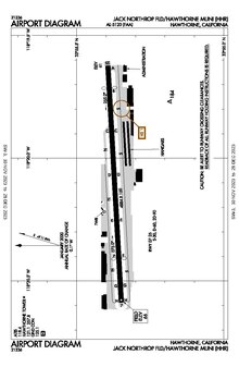 FAA airport diagram | |||||||||||
 HHR Location  HHR HHR (the United States) | |||||||||||
| Runways | |||||||||||
| |||||||||||
Hawthorne Municipal Airport ( IATA: HHR, ICAO: KHHR) (also known as Jack Northrop Field) is a public use airport in Hawthorne, California, United States. It is owned by the City of Hawthorne.
History
The name "Jack Northrop Field" comes from the Northrop Aircraft Corporation, founded by Jack Northrop, which for years designed, built and flew many classic airplanes including YB-35 flying wing, the P-61 Black Widow and F-89 Scorpion night fighters, the F-5 Freedom Fighter, and the T-38 Talon jet trainer. [1]
During World War II, the airfield was used by the United States Army Air Forces Air Technical Service Command as an aircraft modification center and Air Transport Command to ferry new aircraft to operational units.
SpaceX and its spinoff The Boring Company are headquartered at the southeast end of the airport. The Boring Test Tunnel cuts runs just under the fence line at the north-east corner before running under West 120th Street. The Tesla Design Studio is located at the airport as well. [2]
Facilities
The airport covers 80 acres (32 ha); its one runway, 7/25, is 4,884 ft × 100 ft (1,489 m × 30 m) concrete. It is effectively crammed into a very small space and is surrounded by residential areas on all sides. The airport is also in very close proximity to the considerably larger Los Angeles International Airport, so special consideration must be given attention to avoid encroaching on the LAX airspace.
There is one fixed-base operator (FBO) at the airport, Jet Center Los Angeles, a subsidiary of Advanced Air. There is also one other aviation related business on the airfield, Star Helicopters. [3]
Airline and destinations
| Airlines | Destinations | Refs |
|---|---|---|
| Advanced Air |
Crescent City,
Merced Seasonal: Mammoth Lakes | [4] |
Ground Transportation
The Crenshaw station is walking distance from the airport. Several Metro bus lines also run along Crenshaw Boulevard.
See also
References
![]() This article incorporates
public domain material from the
Air Force Historical Research Agency
This article incorporates
public domain material from the
Air Force Historical Research Agency
- ^ "Hawthorne Municipal Airport's roots lie in the early days of the aerospace industry | South Bay History". blogs.dailybreeze.com. Retrieved 2021-01-08.
- ^ "Hawthorne Airport FAQ" (PDF).
- ^ "KHHR – Jack Northrop Field/Hawthorne Municipal Airport". AirNav. Retrieved 2023-12-22.
- ^ "Route Map". Advanced Air. March 8, 2024. Retrieved April 18, 2024.
- Airport Master Record (FAA Form 5010) Archived 2007-01-30 at the Wayback Machine, also available as a printable form Archived 2012-06-06 at the Wayback Machine ( PDF)
- Hawthorne Municipal Airport (City of Hawthorne website)
- AirNav KHHR
- Second FBO Opens at SoCal's Hawthorne Airport
External links
- FAA Airport Diagram ( PDF), effective April 18, 2024