Hato Viejo | |
|---|---|
Barrio | |
.jpg) Historic Manatí Bridge at Mata de Plátano | |
 Location of Hato Viejo within the municipality of Ciales shown in red | |
 Hato Viejo Location of Puerto Rico | |
| Coordinates: 18°20′33″N 66°31′21″W / 18.342604°N 66.522396°W [1] | |
| Commonwealth | |
| Municipality | |
| Area | |
| • Total | 13.23 sq mi (34.3 km2) |
| • Land | 13.17 sq mi (34.1 km2) |
| • Water | 0.06 sq mi (0.2 km2) |
| Elevation | 715 ft (218 m) |
| Population (2010) | |
| • Total | 2,442 |
| • Density | 185.4/sq mi (71.6/km2) |
| Source: 2010 Census | |
| Time zone | UTC−4 ( AST) |
Hato Viejo is a barrio in the municipality of Ciales, Puerto Rico. Its population in 2010 was 2,442. [3] [4] [5] Hato Viejo has more than a dozen sectors, a historic bridge, and folklore about a boy and a cave.
History
Hato Viejo was in Spain's gazetteers [6] until Puerto Rico was ceded by Spain in the aftermath of the Spanish–American War under the terms of the Treaty of Paris of 1898 and became an unincorporated territory of the United States. In 1899, the United States Department of War conducted a census of Puerto Rico finding that the population of Hato Viejo barrio was 1,800. [7]
In August 2020, the United States released Federal Emergency Management Agency funds in support of the coffee industry, directly benefitting a coffee processing plant in Hato Viejo barrio. The funds were appropriated in response to millions of dollars lost by the agricultural industry of Puerto Rico when Hurricane Maria hit Puerto Rico on September 20, 2017. [8]
| Census | Pop. | Note | %± |
|---|---|---|---|
| 1900 | 1,800 | — | |
| 1910 | 2,077 | 15.4% | |
| 1920 | 1,883 | −9.3% | |
| 1930 | 2,719 | 44.4% | |
| 1940 | 2,930 | 7.8% | |
| 1950 | 1,951 | −33.4% | |
| 1960 | 1,842 | −5.6% | |
| 1970 | 1,397 | −24.2% | |
| 1980 | 1,518 | 8.7% | |
| 1990 | 2,232 | 47.0% | |
| 2000 | 2,444 | 9.5% | |
| 2010 | 2,442 | −0.1% | |
| U.S. Decennial Census 1899 (shown as 1900) [9] 1910-1930 [10] 1930-1950 [11] 1980-2000 [12] 2010 [13] | |||
Features
The Manatí Bridge at Mata de Plátano, built in 1905, is located in Hato Viejo and is touted as a tourist site. It connects Ciales to Manatí, a neighboring municipality. [14]
Sectors
Barrios (which are roughly comparable to minor civil divisions) [15] in turn are further subdivided into smaller local populated place areas/units called sectores (sectors in English). The types of sectores may vary, from normally sector to urbanización to reparto to barriada to residencial, among others. [16] [17] [18]
The following sectors are in Hato Viejo barrio: [19]
Sector Caliche, Sector Campamento, Sector Cuchillas, Sector Cumbre, Sector El Cuco, Sector La Grama, Sector Las Lajas, Sector Las Lomas, Sector Los Arnao, Sector Los Barberos, Sector Los Rosa, Sector Los Otero, Urbanización Alturas de Ciales, and Urbanización Monterrey.
Folklore
El niño de Caliche is a legend about a boy from Caliche Sector. The legend says a mother who was working picking fruit had her son with her and that because he kept frolicking around her, she asked him to stay in the cave while she labored. Each time she took him to the cave he followed her back to work. In her final attempt to have her son wait for her at the cave while she worked she sang him a song as she slowly walked away. One verse song reads, "...Ay, turulete, Ay turulete, que el que no tiene vaca no bebe leche.." ( transl. Oh, turulete, oh turulete, he who has no cow, drinks no milk...). [20] She never returned for the boy, night fell, and the boy began to cry. Locals say they hear a boy crying near the cave, and see him frolicking and when they try to catch him, he disappears, only to reappear again steps away. [21]
Gallery
-
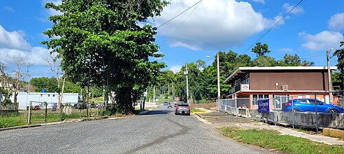 Puerto Rico Highway 6633 in Hato Viejo

See also
References
- ^ a b "US Gazetteer 2019". US Census. US Government.
- ^ U.S. Geological Survey Geographic Names Information System: Hato Viejo barrio
- ^ Picó, Rafael; Buitrago de Santiago, Zayda; Berrios, Hector H. Nueva geografía de Puerto Rico: física, económica, y social, por Rafael Picó. Con la colaboración de Zayda Buitrago de Santiago y Héctor H. Berrios. San Juan Editorial Universitaria, Universidad de Puerto Rico,1969.
- ^ Gwillim Law (20 May 2015). Administrative Subdivisions of Countries: A Comprehensive World Reference, 1900 through 1998. McFarland. p. 300. ISBN 978-1-4766-0447-3. Retrieved 25 December 2018.
- ^ Puerto Rico: 2010 Population and Housing Unit Counts.pdf (PDF). U.S. Dept. of Commerce, Economics and Statistics Administration, U.S. Census Bureau. 2010.
- ^ "Anuario del comercio, de la industria, de la magistratura y de la administración. 1881". Biblioteca Nacional de España (in Spanish). p. 1614. Retrieved 4 April 2023.
- ^ Joseph Prentiss Sanger; Henry Gannett; Walter Francis Willcox (1900). Informe sobre el censo de Puerto Rico, 1899, United States. War Dept. Porto Rico Census Office (in Spanish). Imprenta del gobierno. p. 161.
- ^ "FEMA libera $2.6 millones para invertir en la agricultura local". Villalba Online (in Spanish). 2020-08-26. Retrieved 2021-01-04.
- ^ "Report of the Census of Porto Rico 1899". War Department Office Director Census of Porto Rico. Archived from the original on July 16, 2017. Retrieved September 21, 2017.
- ^ "Table 3-Population of Municipalities: 1930 1920 and 1910" (PDF). United States Census Bureau. Archived (PDF) from the original on August 17, 2017. Retrieved September 21, 2017.
- ^ "Table 4-Area and Population of Municipalities Urban and Rural: 1930 to 1950" (PDF). United States Census Bureau. Archived (PDF) from the original on August 30, 2015. Retrieved September 21, 2014.
- ^ "Table 2 Population and Housing Units: 1960 to 2000" (PDF). United States Census Bureau. Archived (PDF) from the original on July 24, 2017. Retrieved September 21, 2017.
- ^ Puerto Rico: 2010 Population and Housing Unit Counts.pdf (PDF). U.S. Dept. of Commerce Economics and Statistics Administration U.S. Census Bureau. 2010. Archived (PDF) from the original on 2017-02-20. Retrieved 2019-08-02.
- ^ Cruz Rí, Melissa (2018-09-22). "Ciales listo para el turismo". El Vocero de Puerto Rico (in Spanish). Retrieved 2021-04-09.
- ^ "US Census Barrio-Pueblo definition". factfinder.com. US Census. Archived from the original on 13 May 2017. Retrieved 5 January 2019.
- ^ "Agencia: Oficina del Coordinador General para el Financiamiento Socioeconómico y la Autogestión (Proposed 2016 Budget)". Puerto Rico Budgets (in Spanish). Retrieved 28 June 2019.
- ^ Rivera Quintero, Marcia (2014), El vuelo de la esperanza: Proyecto de las Comunidades Especiales Puerto Rico, 1997-2004 (first ed.), San Juan, Puerto Rico Fundación Sila M. Calderón, ISBN 978-0-9820806-1-0
- ^ "Leyes del 2001". Lex Juris Puerto Rico (in Spanish). Retrieved 24 June 2020.
- ^ "DESGLOSE DE SECTORES Y CENTROS DE VOTACIÓN CIALES 023" (PDF). Comisión Estatal de Elecciones Puerto Rico (in Spanish). 19 October 2018. Retrieved 15 June 2020.
- ^ Delgado, Juan M. (2015). "El niño de Caliche" [The boy of Caliche] (PDF). Ciales: Ayer y hoy, Inc. (in Spanish). ciales.tripod.com: Ciales. pp. 57–60. Retrieved January 4, 2022.
- ^ Domínguez Cristóbal, Carlos M. (2007). "Leyendas indigenas de la zona del carso norteño de Puerto Rico: el caliche de Ciales" [Indigenous legends from the north karst zone of Puerto Rico: Caliche of Ciales] (pdf). Acta Cientifica (in Spanish). 21 (1–3): 83.