Hato Rey Norte | |
|---|---|
 Hato Rey Norte skyline, with Martín Peña Canal and
José Miguel Agrelot Coliseum | |
 Location of Hato Rey Norte shown in yellow | |
| Coordinates: 18°25′26″N 66°04′58″W / 18.423962°N 66.082909°W [1] | |
| Commonwealth | |
| Municipality | |
| Area | |
| • Total | 4.33 sq mi (11.2 km2) |
| • Land | 3.57 sq mi (9.2 km2) |
| • Water | 0.76 sq mi (2.0 km2) |
| Elevation | 0 ft (0 m) |
| Population (2010)
[3] | |
| • Total | 16,378 |
| • Density | 4,639.7/sq mi (1,791.4/km2) |
| 2010 census | |
Hato Rey Norte is one of the 18 barrios of the municipality of San Juan, Puerto Rico. Hato Rey Norte was part of the former municipality of Rio Piedras, before it was merged with the municipality of San Juan in 1951.
It is bounded by Hato Rey Central to the east, the districts of Gobernador Piñero and Hato Rey Sur to the south, and by Santurce to the north. The Caño Martín Peña separates Hato Rey Norte from Santurce.
Demographics
| Census | Pop. | Note | %± |
|---|---|---|---|
| 1950 | 8,282 | — | |
| 1960 | 18,658 | 125.3% | |
| 1970 | 18,525 | −0.7% | |
| 1980 | 15,909 | −14.1% | |
| 1990 | 16,002 | 0.6% | |
| 2000 | 16,461 | 2.9% | |
| 2010 | 16,378 | −0.5% | |
| U.S. Decennial Census 1900 (N/A) [4] 1910-1930 [5] 1930-1950 [6] 1980-2000 [7] 2010 [8] | |||
The population of this barrio is of 16,378 residents with a population density of 4,640 residents per square mile.
Subbarrios
The barrio of Hato Rey Norte is further subdivided into four subbarrios. [9]
Landmarks and places of interest
- Banco Popular Center and Caribbean Cinema's Fine Arts Café.
- FBI San Juan Field Office and Degetau Federal Building.
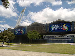
- Hiram Bithorn Stadium, a baseball park listed in the National Register of Historic Places. [10]
- José Miguel Agrelot Coliseum, popularly known as the Choliseo, a basketball arena and San Juan's main concert venue.
- Martín Peña Channel and boardwalk or lineal park (eastern end).
- Milla de Oro, the central business district of San Juan.
- Plaza Las Américas, the largest shopping mall in the Caribbean.
- Puerto Rico Police Department Headquarters.
- Roberto Clemente Coliseum, an indoor arena and concert venue.
- United States Federal Court for the District of Puerto Rico.
Transportation
Hato Rey Norte is part of the Milla de Oro and San Juan central business district, served by the Domenech, Roosevelt and Hato Rey metro stations. The area is also served by the Martín Peña Channel ferry, and the district is also considered a hub for the Metropolitan Bus Authority (AMA).
Gallery
-

-

-
 Luis Muñoz Rivera Avenue at the Milla de Oro.
 -
 Plaza Las Americas Tower
 -
 Jose Miguel Agrelot Coliseum ("Choliseo")
 -
-


.jpg)
_01.jpg)


See also
References
- ^ a b "US Gazetteer 2019". US Census. US Government.
- ^ U.S. Geological Survey Geographic Names Information System: Hato Rey Norte barrio
- ^ "Profile of General Population and Housing Characteristics: 2010". Census.gov. Archived from the original on May 21, 2019. Retrieved November 10, 2012.
- ^ "Report of the Census of Porto Rico 1899". War Department Office Director Census of Porto Rico. Archived from the original on July 16, 2017. Retrieved September 21, 2017.
- ^ "Table 3-Population of Municipalities: 1930 1920 and 1910" (PDF). United States Census Bureau. Archived (PDF) from the original on August 17, 2017. Retrieved September 21, 2017.
- ^ "Table 4-Area and Population of Municipalities Urban and Rural: 1930 to 1950" (PDF). United States Census Bureau. Archived (PDF) from the original on August 30, 2015. Retrieved September 21, 2014.
- ^ "Table 2 Population and Housing Units: 1960 to 2000" (PDF). United States Census Bureau. Archived (PDF) from the original on July 24, 2017. Retrieved September 21, 2017.
- ^ Puerto Rico: 2010 Population and Housing Unit Counts.pdf (PDF). U.S. Dept. of Commerce Economics and Statistics Administration U.S. Census Bureau. 2010. Archived (PDF) from the original on 2017-02-20. Retrieved 2019-08-02.
- ^ "US Census definition of "subbarrio"". factfinder.com. US Census. Archived from the original on 12 February 2019. Retrieved 5 January 2019.
- ^ "National Register of Historic Places listings in San Juan, Puerto Rico", Wikipedia, 2021-05-23, retrieved 2021-10-14

|
| This San Juan, Puerto Rico location article is a stub. You can help Wikipedia by expanding it. |