 100 Block East Hastings Street (north side) near Columbia Street | |
| Part of | |
|---|---|
| Namesake | George Fowler Hastings |
| Length | 13.4 km (8.3 mi) [1] |
| Location | Vancouver, Burnaby, British Columbia, Canada |
| Nearest metro station | Waterfront station |
| West end | Cardero Street |
| Major junctions |
Granville Street Main Street Hwy 1 (TCH) Barnet Highway |
| East end | Burnaby Mountain Parkway |
Hastings Street is one of the most important east-west traffic corridors in the cities of Vancouver and Burnaby, British Columbia, Canada, [2] and used to be a part of the decommissioned Highway 7A. In the central business district of Downtown Vancouver, it is known as West Hastings Street; at Carrall Street it becomes East Hastings Street and runs eastwards through East Vancouver and Burnaby. In Burnaby, there is no east-west designation. The street ends in Westridge, a neighbourhood at the foot of Burnaby Mountain where it joins the recently built Burnaby Mountain Parkway and diverges from the continuation of the former Highway 7A as the Barnet Highway, to Port Moody, British Columbia.
Route description
Formally named in 1885 for Rear-Admiral George Fowler Hastings of the Royal Navy, [3] the street runs past such well-known Vancouver landmarks as the Marine Building, the Vancouver Club, Sinclair Centre, Harbour Centre (once Spencer's, Eaton's, then Sears and now the downtown campus of Simon Fraser University), Dominion Building and Victory Square (the location of the city's original courthouse) and the Woodward's Building; located in the old Dunn's Tailors building at Homer and West Hastings is the campus of the Vancouver Film School, while on the corner of Cambie is the Carter-Cotton Building, the former headquarters of the Vancouver Province newspaper. East of Woodward's, the street forms the heart of Vancouver's historic original downtown, once known as the Great White Way because of its neon displays, and which is today the Downtown Eastside. Through the East End, after a stretch of warehouse-type commercial and wholesale businesses, the street forms one of the commercial cores for Vancouver's Italian community in a mixed-ethnicity retail area in the area of Nanaimo Street, just east of which the Pacific National Exhibition and Playland are on the city of Vancouver's eastern fringe. After leaving Vancouver, Hastings forms the core of a Burnaby retail neighbourhood known as the Heights and then traverses Capitol Hill to the Lochdale and Westridge areas.
Major intersections
From west to east.
| Location | km [1] | mi | Destinations | Notes | |
|---|---|---|---|---|---|
| Vancouver | 0.0 | 0.0 | Cardero Street | ||
| 0.0– 0.1 | 0.0– 0.062 | Bicycles & pedestrians only | |||
| 0.1 | 0.062 | Nicola Street | |||
| 1.0 | 0.62 | Burrard Street | |||
| 1.2 | 0.75 | Howe Street to Hwy 99 south | One-way, southwest bound; west end of former Hwy 7A concurrency | ||
| 1.3 | 0.81 | Granville Street |
Granville Mall (transit only) south of Hastings Street; near
| ||
| 1.4 | 0.87 | Seymour Street | One-way, northeast-bound | ||
| 1.8 | 1.1 | Cambie Street | |||
| 2.2 | 1.4 | Carrall Street | One-way, southbound; division between West and East Hastings | ||
| 2.5 | 1.6 | Main Street | |||
| 4.1 | 2.5 | Clark Drive | |||
| 4.6 | 2.9 | Commercial Drive | |||
| 5.6 | 3.5 | Nanaimo Street | |||
| 6.5 | 4.0 | Renfrew Street | Access to Hastings Park | ||
| 7.4 | 4.6 | Hwy 1 passes underneath Hastings Street via the Cassiar Tunnel; Hwy 1 exit 26 | |||
| Vancouver–Burnaby boundary | 8.0 | 5.0 | Boundary Road | ||
| Burnaby | 9.5 | 5.9 | Willingdon Avenue | ||
| 12.8 | 8.0 | Inlet Drive (to Barnet Highway) | East end of former Hwy 7A concurrency; through traffic follows Inlet Drive | ||
| 13.4 | 8.3 | Dalla Tina Avenue | Becomes Burnaby Mountain Parkway | ||
| 15.4 | 9.6 | Galgardi Way / University Drive | Continues as University Drive East to Simon Fraser University | ||
1.000 mi = 1.609 km; 1.000 km = 0.621 mi
| |||||
Photos
-
 West Hastings, looking east from Harbour Centre
 -
 200 Block East Hastings Street (north side) near Main Street, Downtown Eastside, Vancouver
 -
 East Hastings Street, Vancouver. Looking east from Victoria Drive.
 -
 East Hastings Street in East Vancouver, between Cassiar St. and Skeena St.
 -

-
 Hastings Street joins Inlet Drive (on the left) while continuing uphill towards Simon Fraser University. Eagle Ridge and Westridge in the distance.
 -
 Hastings and Granville, Vancouver, featuring a streetcar and folk in formal wear, circa 1905
 -
 Looking northwest towards the Marine Building from Granville Street, circa 1945.
 -
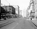
 West Hastings, looking eastward from the corner of Granville Street, circa 1911
 -
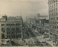 View looking westward from Cambie Street. Probably taken from an upper floor or the roof of the Carter-Cotton Building. March 1, 1912. The Dominion Building is on the right-hand side of the frame.
 -
 A trolley bus on Hastings Street in downtown in 1981


.jpg)
.jpg)

External links
-
 Media related to
Hastings Street (Vancouver) at Wikimedia Commons
Media related to
Hastings Street (Vancouver) at Wikimedia Commons
References
- ^ a b Google (September 16, 2021). "Hastings Street in Vancouver and Burnaby" (Map). Google Maps. Google. Retrieved September 16, 2021.
- ^ "101 West Hastings Street: Urban Design Guidelines Administrative Report, City of Vancouver, April 6, 2004". Archived from the original on September 30, 2007. Retrieved February 2, 2007.
- ^ Snyders, Tom. Namely Vancouver. 2001. Arsenal Pulp Press.