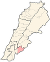
Hasbaya District | |
|---|---|
District | |
 Hasbaya District | |
 Location in Lebanon | |
| Country | |
| Governorate | Nabatiyeh Governorate |
| Capital | Hasbaya |
| Area | |
| • Total | 102 sq mi (265 km2) |
| Population | |
| • Estimate (31 December 2017) | 37,784 |
| Time zone | UTC+2 ( EET) |
| • Summer ( DST) | UTC+3 ( EEST) |
The Hasbaya District is a district in the Nabatiyeh Governorate of Lebanon. It lies in the southeast, bordering Syria. The capital of the district is Hasbaya.
33°23′55″N 35°40′58″E / 33.3985°N 35.6829°E


