Hartsfield, Georgia | |
|---|---|
 Hartsfield, Georgia | |
| Coordinates: 31°13′01″N 83°58′34″W / 31.21694°N 83.97611°W | |
| Country | United States |
| State | Georgia |
| County | Colquitt |
| Elevation | 344 ft (105 m) |
| Time zone | UTC-5 ( Eastern (EST)) |
| • Summer ( DST) | UTC-4 (EDT) |
| ZIP code | 31756 |
| Area code | 229 |
| GNIS feature ID | 331923 [1] |
Hartsfield is an unincorporated community in Colquitt County, Georgia, United States. The community is located on Georgia State Route 37, 11.4 miles (18.3 km) west-northwest of Moultrie. Hartsfield has a post office with ZIP code 31756, which opened on April 21, 1875. [2] [3]
The community was named after John L. Hartsfield, the proprietor of a local sawmill. [4]
References
- ^ "Hartsfield". Geographic Names Information System. United States Geological Survey, United States Department of the Interior.
- ^ United States Postal Service. "USPS - Look Up a ZIP Code". Retrieved November 21, 2015.
- ^ "Postmaster Finder - Post Offices by ZIP Code". United States Postal Service. Retrieved November 21, 2015.
- ^ Krakow, Kenneth K. (1975). Georgia Place-Names: Their History and Origins (PDF). Macon, GA: Winship Press. p. 105. ISBN 0-915430-00-2.
Municipalities and communities of
Colquitt County, Georgia, United States | ||
|---|---|---|
| Cities | 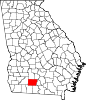 | |
| Towns | ||
|
Unincorporated communities | ||
| Footnotes | ‡This populated place also has portions in an adjacent county or counties | |
|
| This Colquitt County, Georgia state location article is a stub. You can help Wikipedia by expanding it. |