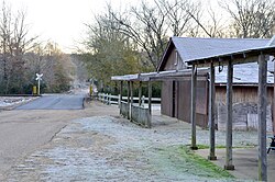
Hardy, Mississippi | |
|---|---|
 Hardy | |
| Coordinates: 33°52′55″N 89°49′46″W / 33.88194°N 89.82944°W | |
| Country | United States |
| State | Mississippi |
| County | Grenada |
| Elevation | 246 ft (75 m) |
| Time zone | UTC-6 ( Central (CST)) |
| • Summer ( DST) | UTC-5 (CDT) |
| ZIP code | 38901 |
| Area code | 662 |
| GNIS feature ID | 693415 [1] |
Hardy is an unincorporated community located in Grenada County, Mississippi and part of the Grenada Micropolitan Statistical Area . Hardy is approximately 10 miles (16 km) north of Grenada near Interstate 55.
The community was named for Richard Hardy, who owned the land on which the railroad depot was built. [2]
Hardy is located on the former Illinois Central Railroad. [3]
A post office operated under the name Hardy from 1868 to 1966. [4]
References
- ^ U.S. Geological Survey Geographic Names Information System: Hardy, Mississippi
- ^ Rowland, Dunbar (1907). Mississippi: Comprising Sketches of Counties, Towns, Events, Institutions, and Persons, Arranged in Cyclopedic Form. Vol. 1. Southern Historical Publishing Association. p. 838.
- ^ Howe, Tony. "Hardy, Mississippi". Mississippi Rails. Retrieved February 12, 2021.
- ^ "Grenada County". Jim Forte Postal History. Retrieved February 12, 2021.


