Halsteren
Altere | |
|---|---|
Town | |
 Former town hall of Halsteren | |
 Halsteren Location in the province of North Brabant in the Netherlands  Halsteren Halsteren (Netherlands) | |
| Coordinates: 51°31′N 4°16′E / 51.517°N 4.267°E | |
| Country | Netherlands |
| Province | North Brabant |
| Municipality | Bergen op Zoom |
| Area | |
| • Total | 16.43 km2 (6.34 sq mi) |
| Elevation | 6 m (20 ft) |
| Population (2021)
[1] | |
| • Total | 12,325 |
| • Density | 750/km2 (1,900/sq mi) |
| Time zone | UTC+1 ( CET) |
| • Summer ( DST) | UTC+2 ( CEST) |
| Postal code | 4661
[1] |
| Dialing code | 0164 |
Halsteren is a town in the Dutch province of North Brabant. It is located in the municipality of Bergen op Zoom, about 1 km north of that city. Halsteren has an old church from the 14th century and a new church, built in 1919. A little village called Polder was located between Halsteren and Tholen in the Middle Ages.
History
The village was first mentioned in 1272 as Halstert, and means "bend in the highland with a tail". It developed on a westward pointing sandy ridge. [3]
The Dutch Reformed church was built in the 14th century. It was extended in 1457. After a fire in 1607, it was extensively restored. In 1799, it was returned to the Catholic church and restored several times. In 1961, it became a Dutch Reformed church again. The Catholic St. Quirinus Church was built between 1911 and 1912 and has a double tower. The former town hall dates from 1633. It was restored and extended in 1917. It was restored in 1944 after a fire. [4]
Halsteren was home to 538 people in 1840. [5] Halsteren was a separate municipality until 1997, when it became a part of Bergen op Zoom. [6]
The village of Polder or Polre was located near Halsteren. It disappeared in a flood in 1570 and most of the village is still buried underneath a metre of mud. [5]
Gallery
-
 Windmill: the Sint Antoniusmolen
 -
 Farm in Halsteren
 -
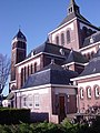 Quirinus Church
 -
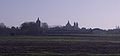 View on Halsteren


References
- ^ a b c "Kerncijfers wijken en buurten 2021". Central Bureau of Statistics. Retrieved 15 April 2022.
- ^ "Postcodetool for 4661AA". Actueel Hoogtebestand Nederland (in Dutch). Het Waterschapshuis. Retrieved 15 April 2022.
- ^ "Halsteren - (geografische naam)". Etymologiebank (in Dutch). Retrieved 15 April 2022.
- ^ Chris Kolman & Ronald Stenvert (1997). Halsteren (in Dutch). Zwolle: Waanders. ISBN 90 400 9945 6. Retrieved 15 April 2022.
- ^ a b "Halsteren". Plaatsengids (in Dutch). Retrieved 15 April 2022.
- ^ Ad van der Meer and Onno Boonstra, Repertorium van Nederlandse gemeenten, KNAW, 2011.
External links
-
 Media related to
Halsteren at Wikimedia Commons
Media related to
Halsteren at Wikimedia Commons - Information about Halsteren on the site of the BHIC (Dutch)
| Authority control databases: Geographic |
|---|