| Haitón del Guarataro | |
|---|---|
 Entrance shaft of Haitón del Guarataro | |
.svg) Location of Haitón del Guarataro within Venezuela | |
| Location | Falcón State, Venezuela |
| Coordinates | 11°08′59″N 69°41′23″W / 11.149748°N 69.689774°W |
| Depth | 305 metres (1,001 ft) |
| Length | 640 metres (2,100 ft) |
| Elevation | 1,000 metres (3,300 ft) |
| Discovery | April 1973 |
| Geology | Oligocene limestone |
| Entrances | 1 |
| Hazards | Verticality |
| Cave survey | BKRE 1973 |
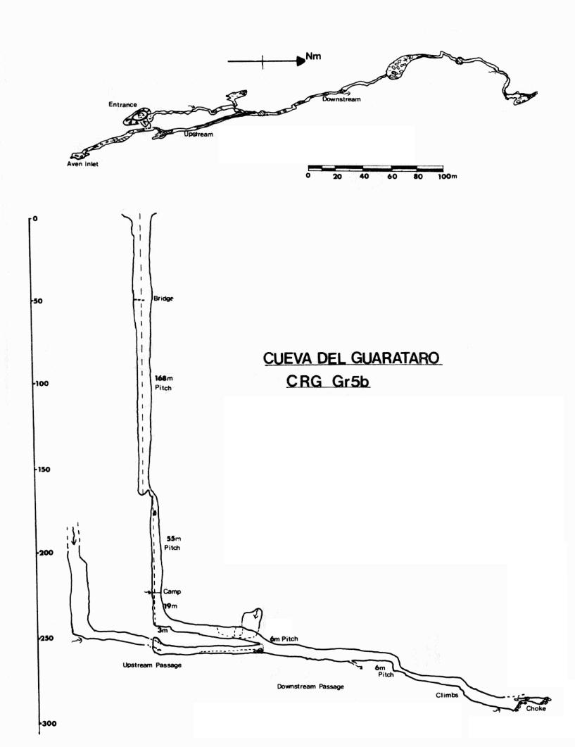
The Haitón del Guarataro is a solutional cave system in the Sierra de San Luis in Falcón State, Venezuela, 2.5 kilometres (1.6 mi) south-east of Curimagua. It is the deepest limestone cave in Venezuela, [1] and the entrance is a tourist attraction within the Juan Crisóstomo Falcón National Park. [2] A large entrance shaft 12 metres (39 ft) in diameter leads via drops of 168 metres (551 ft), 55 metres (180 ft), and 19 metres (62 ft) to a stream passage which follows the dip down for a distance of about 350 metres (1,150 ft) to the north to where it eventually chokes. An upstream passage is intercepted which runs south for about 150 metres (490 ft) to the base of a shaft. The cave has a depth of 305 metres (1,001 ft), and a total passage length of 640 metres (2,100 ft). It was first explored and surveyed in April 1973 by members of the Venezuela '73 British Karst Research Expedition. [3] [4] It is formed in Oligocene reefal limestone. [5]
A faunal survey was undertaken during the exploration of the cave, but only a few cavernicoles were recorded. They included cave crickets, phalangodid harvestmen, a depigmented troglophile garnmarid shrimp ( Hyalella meinerti) found in a large pool, and a troglobitic trichopolydesmid millipede found on the roof of the terminal chamber. [6]
References
- ^ Herrera, Francisco; et al. (2006). "Sociedad Venezolana de Espeleología 2007". Boletín de la Sociedad Venezolana de Espeleología. 40: 5–11. Archived from the original on 6 November 2014. Retrieved 24 February 2020.
- ^ Kohn, Beth (2007). Lonely Planet Venezuela. Lonely Planet. p. 154. ISBN 9781741045451. Retrieved 3 February 2016.
- ^ Chapman, Phil; Checkley, Dave (March 1981). "Caves of the Serrania de San Luis, Edo Falcon: The British Karst Research Expedition to Venezuela, 1973" (PDF). Transactions of the British Cave Research Association. 8 (1): 1–26. Retrieved 24 February 2021.
- ^ Gascoyne, Melvyn (September 1974). "Hydrological Investigations in Northern Venezuela" (PDF). Transactions of the British Cave Research Association. 1 (3): 169–179. Retrieved 24 February 2021.
- ^ Gunn, John, ed. (2004). Encyclopedia of Caves and Karst Science. London: Fitzroy Dearborn. p. 110. ISBN 978-1579583996.
- ^ Chapman, Phil (December 1980). "The Invertebrate Fauna of Caves of the Serrania de San Luis, Edo Falcon, Venezuela" (PDF). Transactions of the British Cave Research Association. 7 (4): 179–199. Retrieved 24 February 2021.
External links
- The Venezuela '73 British Karst Research Expedition survey of Haitón del Guarataro
- Video of a December 2018 descent by members of the Sociedad Venezolana de Espeleologia
