This article needs additional citations for
verification. (May 2019) |
Hachijō Subprefecture
八丈支庁 | |
|---|---|
| Hachijō-shichō | |
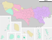
 Location of Hachijō Subprefecture in the
Tokyo Metropolis | |
| Prefecture | Tokyo Metropolis |
| Capital | Hachijō |
| Area | |
| • Total | 78.6 km2 (30.3 sq mi) |
| Population (October 1, 2023) | |
| • Total | 8,790 |
| • Density | 110/km2 (290/sq mi) |
| Website | Official website |
Hachijō Subprefecture (八丈支庁, Hachijō-shichō) is a subprefecture of Tokyo Metropolis, Japan. The organization of government belongs to the Tokyo Metropolitan Government Bureau Of General Affairs.
Geography
The subprefecture has an area of 78.6 square km. It is located within the Izu Islands and is 200km away from Mainland Japan.
Municipalities
| Romanji | Kanji | Area (Km²) | Population | Type | Island(s) | Map |
|---|---|---|---|---|---|---|
| 八丈町 | 72.24 | 7,056 | Town | Hachijō-jima and Hachijō-kojima |
| |
| 青ヶ島村 | 5.96 | 169 | Village | Aogashima |

|
Other Islands
Additionally, Hachijō includes the four southernmost Izu Islands, which are uninhabited. These islands currently do not belong to any municipality; both Hachijō and Aogashima claim administrative rights. From north to south, the islands are:
- Bayonnaise Rocks (Beyonēzu Retsugan)
- Smith Island (Sumisu-tō)
- Tori-shima
- Lot's Wife (Sōfu-iwa)
Among the islands of the subprefecture, only Hachijōjima and Aogashima are inhabited.
Demographics
In 2023, Hachijō Subprefecture had a population of 8,790. The village of Aogashima is the least populated municipality in all of Japan, with only 169 residents [1]
Language
The Hachijō language, also called Shima Kotoba, is spoken exclusively on the two main islands. It is an endangered language, with 0 native speakers being children or young adults. [2]
References
33°06′36″N 139°47′21″E / 33.109916°N 139.789056°E