You can help expand this article with text translated from
the corresponding article in Vietnamese. Click [show] for important translation instructions.
|
Ha Long
Thành phố Hạ Long | |
|---|---|
From top to bottom, from left to right: a view of the city from Bài Thơ mountain, stalactites in Thiên Cung cave,
Hạ Long Bay, resort on Rêu island in
Bãi Cháy ward,
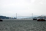
Bãi Cháy Bridge | |
 Seal | |
|
| |
 Ha Long Location in Vietnam | |
| Coordinates: 20°57′N 107°05′E / 20.950°N 107.083°E | |
| Country | |
| Province | Quảng Ninh |
| Government | |
| • Type | People's Committee and People's Council |
| • Chairman of People's Council | Nguyễn Thế Thịnh |
| • Chairman of People's Committee | Phạm Hồng Hà |
| Area | |
| • Total | 1,119.12 km2 (432.09 sq mi) |
| Population (2019 census) | |
| • Total | 270,054 |
| • Density | 240/km2 (620/sq mi) |
| Climate | Cwa |
| Website |
halongcity |

.jpg)


Hạ Long (Vietnamese: [hâːˀ lawŋm] ⓘ; chữ Hán: 下龍; transl. 'descending dragon') is the capital city and first-class provincial city of Quảng Ninh province, Vietnam. It was founded in 1993, when the old capital, Hòn Gai, was merged with Bãi Cháy, the main tourist area. The city mainly lies on Hạ Long Bay, and is located at about 178 km (111 mi) east of Hanoi. The city's population in 2019 was 270,054. [1] [2]
Overview

Hạ Long's economy shifted its economic focus from coal mining to tourism in 2012, due to the large number of visitors drawn by the Hạ Long Bay every year. [3] Hạ Long enjoys rapid growth not only in its own tourism sphere, but also as a destination upon the main pathway to southern China. [4] In the 2007 Vietnam-China Business Forum, a $400 million deal was signed to build a highway linking Hạ Long and the border city of Móng Cái. The highway began construction in 2015 and was completed in 2022. [5]
Hạ Long is divided into two parts. The eastern part, known colloquially as Hòn Gai, where most of the governing offices and industrial infrastructure are concentrated, is connected by a cable-stayed bridge to the western part, Bãi Cháy, known as an area for tourism.
Location
Being a coastal city, Hạ Long bears unique potentials of tourism and seaport due to its land lies along the shore of Hạ Long Bay by 50 km. Hạ Long is 160 km to the north-east from Hanoi, 60 km to the East from Haiphong, 180 km to the south-west from Móng Cái international border gate, and bounded by the Gulf of Tonkin to the south. Hạ Long has strategic location of economic development, security of the region and the country.
History
Humankind has been present in Hạ Long for a long time. Archaeologists and historians concluded that during the Stone Age, there had been three cultures known as Soi Nhụ, Hạ Long and Cái Bèo, affirming that the bay and its surrounding areas were one of the cradles of mankind. [6] The heartland of today's Hạ Long is formerly a fishing village named Bãi Hàu ( lit. 'Oyster coast'). By the beginning of the Nguyễn dynasty, it was renamed to Mẫu Lệ. The current city was then part of Hoành Bồ district.
In 1883, during French rule, the French carried out coal mining in the mines on the bay's coast. As many islands were populated with hemp, the French called them Ile des brouilles or a name translated from "Hòn Gai" to "Hòn Gay", and later renamed them Hòn Gai. According to the researchers, "Hòn Gai" is a deviation from the place of the French Red Sea at that time. The "H" is a silent sound when spoken in French. During this period, Hòn Gai was an administrative unit of Quảng Yên province.
After the August Revolution in 1945, this township became the capital town of the huge Hồng Gai mine area. Later in 1946, the French retook Hòn Gai. After the 1954 Geneva Conference, Hòn Gai became the capital of the special district of Hồng Quảng. On October 30, 1963, the Vietnamese government combined Hải Ninh province and Hồng Quảng to establish the province of Quảng Ninh, with Hòn Gai becoming its capital, and the province's boundaries being expanded. The Hòn Gai town center provided coal for all industrial zones of North Vietnam. It was also one of the gateways that lead to China, and as such, it was frequently targeted by U.S. forces during the Vietnam War. The Bãi Cháy ferry line (decommissioned in 2007 and replaced by the Bãi Cháy Bridge) was the most important transportation hub, was the target of many U.S. bombardments, and was awarded Hero of the People's Armed Forces three times.
On December 27, 1993, the government issued Decree No. 102/CP, where Hòn Gai officially gained city status and was renamed to Hạ Long, while also incorporating Bãi Cháy into its territory.
On December 17, 2019, the city's committee announced its intention to incorporate Hoành Bồ into its territory. [7]
Climate
| Climate data for Hạ Long ( Bãi Cháy) | |||||||||||||
|---|---|---|---|---|---|---|---|---|---|---|---|---|---|
| Month | Jan | Feb | Mar | Apr | May | Jun | Jul | Aug | Sep | Oct | Nov | Dec | Year |
| Record high °C (°F) | 28.8 (83.8) |
29.5 (85.1) |
32.0 (89.6) |
34.6 (94.3) |
36.1 (97.0) |
37.3 (99.1) |
37.9 (100.2) |
36.5 (97.7) |
36.3 (97.3) |
34.1 (93.4) |
33.8 (92.8) |
29.7 (85.5) |
37.9 (100.2) |
| Mean daily maximum °C (°F) | 19.3 (66.7) |
19.7 (67.5) |
22.0 (71.6) |
26.1 (79.0) |
30.1 (86.2) |
31.5 (88.7) |
31.7 (89.1) |
31.3 (88.3) |
30.7 (87.3) |
28.8 (83.8) |
25.5 (77.9) |
21.7 (71.1) |
26.5 (79.7) |
| Daily mean °C (°F) | 16.2 (61.2) |
17.0 (62.6) |
19.5 (67.1) |
23.4 (74.1) |
26.9 (80.4) |
28.4 (83.1) |
28.6 (83.5) |
27.9 (82.2) |
27.1 (80.8) |
25.0 (77.0) |
21.5 (70.7) |
17.9 (64.2) |
23.3 (73.9) |
| Mean daily minimum °C (°F) | 14.0 (57.2) |
15.2 (59.4) |
17.8 (64.0) |
21.5 (70.7) |
24.6 (76.3) |
26.0 (78.8) |
26.2 (79.2) |
25.4 (77.7) |
24.4 (75.9) |
22.2 (72.0) |
18.7 (65.7) |
15.3 (59.5) |
20.9 (69.6) |
| Record low °C (°F) | 4.6 (40.3) |
5.3 (41.5) |
7.1 (44.8) |
11.4 (52.5) |
15.9 (60.6) |
18.4 (65.1) |
21.4 (70.5) |
21.1 (70.0) |
16.6 (61.9) |
14.0 (57.2) |
9.0 (48.2) |
5.7 (42.3) |
4.6 (40.3) |
| Average rainfall mm (inches) | 27.7 (1.09) |
24.5 (0.96) |
42.9 (1.69) |
86.3 (3.40) |
183.2 (7.21) |
297.0 (11.69) |
364.3 (14.34) |
430.5 (16.95) |
276.0 (10.87) |
142.6 (5.61) |
38.9 (1.53) |
18.1 (0.71) |
1,923 (75.71) |
| Average rainy days | 7.6 | 10.4 | 14.3 | 11.4 | 12.0 | 15.5 | 16.5 | 18.7 | 14.1 | 9.2 | 5.8 | 5.2 | 140.5 |
| Average relative humidity (%) | 80.4 | 84.0 | 87.1 | 86.5 | 83.3 | 83.8 | 83.6 | 85.6 | 82.5 | 78.5 | 76.7 | 76.3 | 82.4 |
| Mean monthly sunshine hours | 81.2 | 48.3 | 42.9 | 88.7 | 178.2 | 168.4 | 186.8 | 165.2 | 177.1 | 177.3 | 155.7 | 127.7 | 1,595.8 |
| Source: Vietnam Institute for Building Science and Technology [8] | |||||||||||||
Culture and society

In the south of the city lies the Bài Thơ ('Poem') Mountain with its almost vertical seaward face, which was widely traversed by a number of historically known local poets. The limestone peak is rich in biodiversity and offers attractive views of the bay. Other places of interest include the Cửa Vận Fishing Village, Hoàng Gia Park, Hạ Long Market, Bãi Cháy Trading Center, Quảng Ninh Museum and Library, Tuần Châu island, Vietnam-Japan Cultural House, Children's Cultural House, and the Sun World complex. [9]
The city has an active Catholic church in its eastern part, Hòn Gai, on the hill near the main post office, which hosts masses every Sunday evening and on Christian holidays. [10]
Administrative divisions
The city is subdivided to 33 commune-level subdivisions, including 21 wards and 12 rural communes:
| List of administrative divisions in Hạ Long [11] | |||||||||||||||||||||||||||||||||||||||||||||||||||||||||||||||||||||||||||||||||||||||||||||||||||||||||||||||||
|---|---|---|---|---|---|---|---|---|---|---|---|---|---|---|---|---|---|---|---|---|---|---|---|---|---|---|---|---|---|---|---|---|---|---|---|---|---|---|---|---|---|---|---|---|---|---|---|---|---|---|---|---|---|---|---|---|---|---|---|---|---|---|---|---|---|---|---|---|---|---|---|---|---|---|---|---|---|---|---|---|---|---|---|---|---|---|---|---|---|---|---|---|---|---|---|---|---|---|---|---|---|---|---|---|---|---|---|---|---|---|---|---|---|
|
|
||||||||||||||||||||||||||||||||||||||||||||||||||||||||||||||||||||||||||||||||||||||||||||||||||||||||||||||||
Economy
The city comprises five economic areas:
- Area 1: Trading, services including the wards of Yết Kiêu, Trần Hưng Đạo, Hồng Gai, Bạch Đằng, Hồng Hải, Hồng Hà, Cao Xanh and Cao Thắng.
- Area 2: Industry, forestry including the wards of Hà Trung, Hà Tu, Hà Khánh, Hà Lầm and Hà Phong.
- Area 3: Industry, seaports including north-west of Bãi Cháy, north of Việt Hưng, Giếng Đáy and Hà Khẩu.
- Area 4: Tourism, trading including south of Bãi Cháy, Hùng Thắng and Tuần Châu.
- Area 5: Agriculture, fishery including Việt Hưng and Đại Yên.
The structure of Hạ Long's economy includes: Industry-tourism, services, trading, agriculture, forestry and fishery. In 2002, city's GDP increased up to VND 1,6669.7 billion (pricing of 1994), accounting for 38% of the whole province, of which industry and construction occupy 31%, tourism and services occupy 53%; revenue collection accounts for 86.3% of the province. Annual GDP growth rate is 11.4%. GDP per capital reached US$1,070 in 2002, higher than per capita income of the country in that time. [12]
Hạ Long City has 1,470 industry and handicrafts manufacturing units, including coal mining and processing, ship building, building materials, mechanic, wood processing, food, foodstuff and garment. There are 3 industrial zones: Cái Lân (with Cái Lân Port, one of the biggest ports in North Vietnam), Đồng Đăng and Hà Khánh.

Transportation
The Van Don International Airport serves Hạ Long and the wider Quảng Ninh province. It is located approximately 50 km (31 mi) east of Hạ Long.
Gallery
-
-
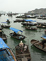 Fishers' boats on bay
 -
 Traditional red sails on Hạ Long style's boat contrast with blue water surface
 -
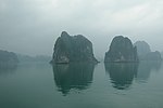
 Limestone islands
 -
 Sailing towards Ha Long Bay
 -
 Ha Long
 -
 Sun Wheel


References
- ^ "Hạ Long (District-level City, Quảng Ninh, Vietnam) - Population Statistics, Charts, Map and Location". www.citypopulation.de. Retrieved 2024-02-07.
- ^ "TP Hạ Long sẽ trở thành đô thị lớn nhất cả nước". blog.mytour.vn (in Vietnamese). 2019-10-07. Retrieved 2023-03-30.
- ^ Hương, Thảo (2022-10-28). "Du lịch Quảng Ninh: Một thập kỷ chuyển mình ngoạn mục". Báo Kinh tế đô thị (in Vietnamese). Retrieved 2023-05-31.
- ^ "Quảng Ninh: Để du lịch trở thành ngành kinh tế mũi nhọn". vietnamtourism.gov.vn (in Vietnamese). 2021-10-26. Retrieved 2023-05-31.
- ^ ONLINE, TUOI TRE (2022-09-01). "Quảng Ninh thông xe cao tốc Vân Đồn - Móng Cái". TUOI TRE ONLINE (in Vietnamese). Retrieved 2023-05-31.
- ^ "Văn hóa Hạ Long giai đoạn hậu kỳ thời đại đồ đá mới". vntravellive.com (in Vietnamese). Retrieved 2023-05-31.
- ^ Decree No. 837/NQ-UBTVQH14
- ^ "Vietnam Institute for Building Science and Technology" (PDF).
-
^ how24h, Hien (2024-03-19).
"Essential Tips for Traveling to Ha Long (How24h.com)" (in Vietnamese). Retrieved 2024-03-19.
{{
cite web}}
: CS1 maint: numeric names: authors list ( link) - ^ "Du lịch Nhà Thờ Hòn Gai - ngôi nhà thờ trên ngọn đồi cao". www.blog.mytour.vn. Retrieved 2023-03-30.
- ^ Hạ Long's population and wards' population till 1/4/2009 Archived 2013-05-16 at the Wayback Machine, Website Hạ Long City .
- ^ Hạ Long-tourist city, Hạ Long People's Committee and Hạ Long People's Council Published in 12/2003, page 40
External links
-
 Media related to
Ha Long at Wikimedia Commons
Media related to
Ha Long at Wikimedia Commons - Official website
- Official website of the provincial government ( Vietnamese)
| Bắc Giang province |  | |
|---|---|---|
| Bắc Kạn province | ||
| Cao Bằng province | ||
| Hà Giang province | ||
| Lạng Sơn province | ||
| Phú Thọ province | ||
| Quảng Ninh province |
| |
| Thái Nguyên province | ||
| Tuyên Quang province | ||
※ denotes provincial seat. | ||
| |||||||||||||||||||||||||||||||||||||||||||||||||||||||||||||||||||||||||||||||||||||||||||||


| 2,000,000 and more |
|
|---|---|
| 1,000,000–1,999,999 | |
| 500,000–999,999 | |
| 200,000–499,999 | |
| International | |
|---|---|
| National | |