Hřensko | |
|---|---|
 | |
| Coordinates: 50°52′28″N 14°14′33″E / 50.87444°N 14.24250°E | |
| Country | |
| Region | Ústí nad Labem |
| District | Děčín |
| First mentioned | 1488 |
| Area | |
| • Total | 19.86 km2 (7.67 sq mi) |
| Elevation | 130 m (430 ft) |
| Population (2023-01-01)
[1] | |
| • Total | 268 |
| • Density | 13/km2 (35/sq mi) |
| Time zone | UTC+1 ( CET) |
| • Summer ( DST) | UTC+2 ( CEST) |
| Postal code | 407 17 |
| Website |
www |
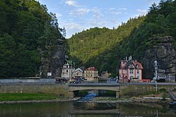
Hřensko ( German: Herrnskretschen) is a municipality and village in Děčín District in the Ústí nad Labem Region of the Czech Republic. It has about 300 inhabitants. With an elevation of 130 metres (430 ft) above sea level, it is the lowest situated municipality in the country. Located on the edge of the Bohemian Switzerland National Park, Hřensko is known for many natural monuments, especially for the Kamenice Gorge and Pravčická brána.
Administrative parts
The village of Mezná is an administrative part of Hřensko.
Geography
Hřensko is located about 11 kilometres (7 mi) north of Děčín. It lies on the border with Germany and is adjacent to Bad Schandau and Schöna. It lies in the Elbe Sandstone Mountains. Most of the municipality lies in the Bohemian Switzerland National Park. The highest point of the municipality is Oltářní kámen at 469 metres (1,539 ft) above the sea.
Hřensko is situated at the confluence of the Kamenice and Elbe rivers, in the Elbe valley. In the municipal territory is located the lowest point of the Czech Republic, which is the Elbe on the border with Germany at 115 metres (377 ft) above the sea.
History
Hřensko was established during the 15th century as a trading settlement. [2]
Demographics
|
|
| ||||||||||||||||||||||||||||||||||||||||||||||||||||||
| Source: Censuses [3] [4] | ||||||||||||||||||||||||||||||||||||||||||||||||||||||||
Transport

There are two border crossings in Hřensko: the Hřensko / Schmilka road border crossing and the Hřensko / Schöna river border crossing.
Sights
The municipality is a portal to the Bohemian Switzerland National Park. The main attractions in the municipal territory are the Kamenice Gorge and Pravčická brána, the largest natural stone bridge in Europe. [5] They are among the most visited nature tourist destinations in the entire country. [6]
In popular culture
Pravčická brána was featured in the film The Chronicles of Narnia: The Lion, the Witch and the Wardrobe. [7]
Notable people
- Erich Clar (1902–1987), German chemist
References
- ^ "Population of Municipalities – 1 January 2023". Czech Statistical Office. 2023-05-23.
- ^ "Historie obce" (in Czech). Obec Hřensko. Retrieved 2021-07-13.
- ^ "Historický lexikon obcí České republiky 1869–2011 – Okres Děčín" (in Czech). Czech Statistical Office. 2015-12-21. pp. 5–6.
- ^ "Population Census 2021: Population by sex". Public Database. Czech Statistical Office. 2021-03-27.
- ^ "O Hřensku" (in Czech). Obec Hřensko. Retrieved 2021-07-13.
- ^ "Turisté mají v České republice nejraději zoologické zahrady, technické památky, koupání a Pražský hrad" (in Czech). CzechTourism. 2022-06-24. Retrieved 2023-01-24.
- ^ "Sedm míst, která znáte z filmů. Vydejte se na výlet" (in Czech). iDnes. 2014-06-30. Retrieved 2022-05-26.


