Grove Place Historic District | |
  | |
| Location | Gibbs, Selden, Grove and Windsor Sts., Rochester, New York |
|---|---|
| Coordinates | 43°9′35″N 77°36′3″W / 43.15972°N 77.60083°W |
| Area | 8.1 acres (3.3 ha) |
| Built | 1845 |
| Architectural style | Late 19th And 20th Century Revivals, Late Victorian |
| MPS | Inner Loop MRA |
| NRHP reference No. | 84000299 [1] |
| Added to NRHP | October 11, 1984 |
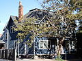
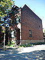
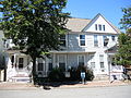
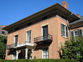
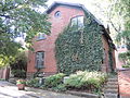
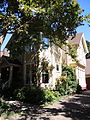
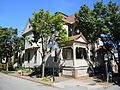
Grove Place Historic District is a national historic district located at Rochester in Monroe County, New York. The district includes all that remains and is associated with "The Grove," the original homestead area of Rochester's Selden and Ward families. It is an enclave of 22 substantially intact small-scale 19th century residences, constructed between about 1850 and 1895, which were built, owned, and occupied by this complex extended family. [2]
It was listed on the National Register of Historic Places in 1984. [1]
- Gibbs Street
-
 125 Gibbs Street
 -
 137 Gibbs Street
 -
 144, 148, and 152 Gibbs Street (a.k.a., "the Townhouse")
 -
 153 Gibbs Street
 -
 158 Gibbs Street
 -
 164 Gibbs Street
 -
 165 and 169 Gibbs Street


- Grove Place
-
 18 and 20 Grove Place
 -
 18 and 20 Grove Place
 -
 18 Grove Place
 -
 20 Grove Place, east side
 -
 23 Grove Place


- Selden Street
-
 3 and 5 Selden Street, east side
 -
 3 and 5 Selden Street, north side
 -
 3 and 5 Selden Street, west side
 -
 14 Selden Street, east side
 -
 14 Selden Street, west side


- Windsor Street
-
 28 and 30 Windsor Street
 -
 38 Windsor Street
 -
 44 and 50 Windsor Street
 -
 51 and 55 Windsor Street


References
- ^ a b "National Register Information System". National Register of Historic Places. National Park Service. March 13, 2009.
- ^ Ted Bartlett (June 1984). "National Register of Historic Places Registration: Grove Place Historic District". New York State Office of Parks, Recreation and Historic Preservation. Archived from the original on September 21, 2012. Retrieved September 1, 2009. See also: "Accompanying 14 photos".
External links
Wikimedia Commons has media related to
Grove Place Historic District.
