 Surface analysis of the storm as it moved through New England
[1] | |
| Type |
Extratropical cyclone Nor'easter Blizzard Winter storm |
|---|---|
| Formed | February 1, 1976 |
| Dissipated | February 5, 1976 |
| Lowest pressure | 957 mb (28.26 inHg) |
| Maximum snowfall or ice accretion | 56 inches (140 cm) |
| Damage | $22 million (Mostly in Canada) |
| Areas affected | New England and Atlantic Canada |
The Groundhog Day gale was a severe winter storm that hit the Northeastern United States and southeastern Canada on February 2 ( Groundhog Day), 1976.
Meteorologist synopsis
An upper-level low was stationary across the Desert Southwest of the United States, on January 28. [2] A system in the northern branch of the Westerlies known as a Saskatchewan Screamer, similar to an Alberta clipper but originating as a frontal wave in the next Canadian province to the east, moved east-southeast across Canada beginning on January 30, luring the system in the United States eastward. The cyclones merged by February 2, becoming a significant storm over New England before lifting northward through Quebec into the Davis Strait. At this time, maximum sustained winds reached 164 kilometers per hour (102 mph) in coastal areas (equal to a Category 2 hurricane on the Saffir-Simpson hurricane scale), with wind gusts of up to 188 kilometers per hour (116 mph). By February 6, this extratropical cyclone was absorbed by another system in the northern Canadian archipelago. [3]
Effects in the United States
Maine
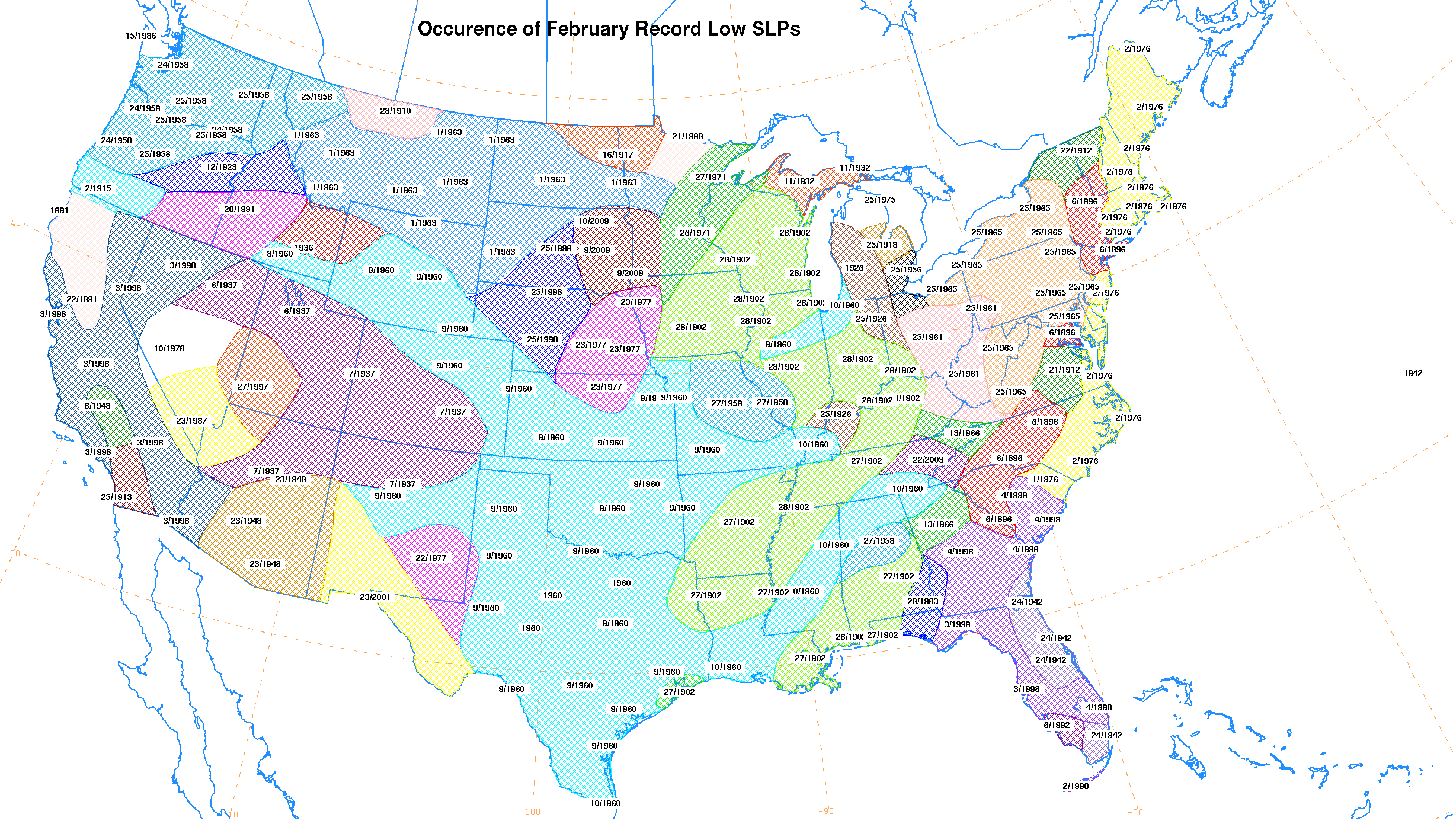
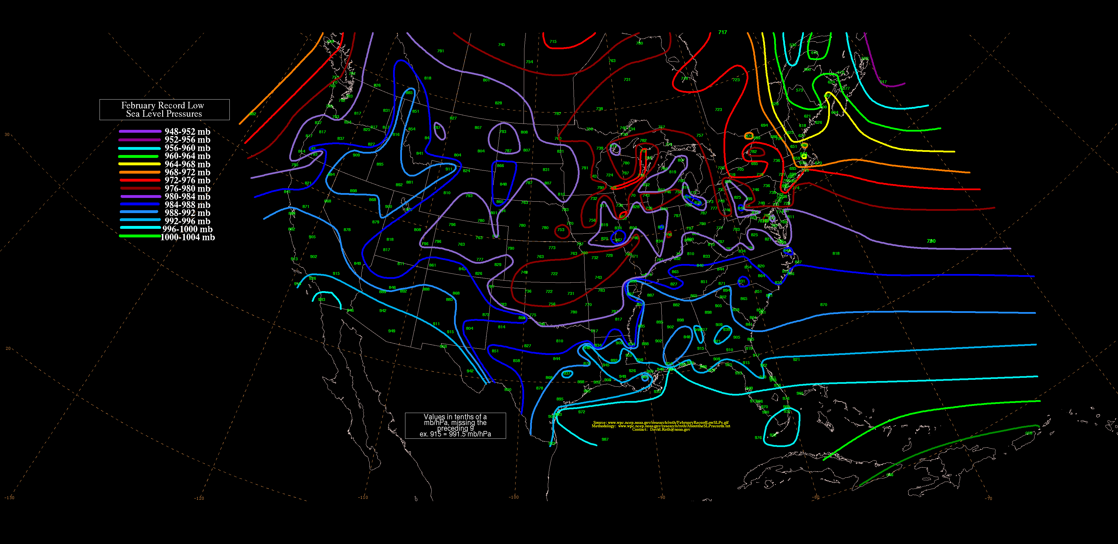
Caribou, Maine, recorded one of its lowest pressures on record, with much of New England recording its lowest values for the month of February, [4] with a reading of 957.3 hectopascals (28.27 inHg). [5] Winds gusted to 60 knots (69 mph) in Rockland and 100 knots (115 mph) at Southwest Harbor. Blizzard conditions were experienced for a few hours as the cyclone moved up into Canada. The storm caused extensive damage in many areas. Although many trees were blown down by the storm, many more were killed after large amounts of seawater were blown inland. Coastal flooding was seen from Brunswick to Eastport. A tidal surge went up the Penobscot River, flooding Bangor, Maine, for three hours around midday. [6] At 11:15 am, waters began rising on the river and within 15 minutes had risen a total of 3.7 metres (12 ft) flooding downtown. About 200 cars were submerged and office workers were stranded until waters receded. There were no reported deaths during this unusual flash flood. [7]
Massachusetts
Boston, Massachusetts, set their lowest February pressure on record, with a reading of 28.48 inches of mercury (964 hPa). [8]
New York
Cyclonic flow and cold air around the backside of this system led to significant Lake effect snows for areas downwind of the Great Lakes. [9]
Vermont
Burlington set a daily snow record on February 2 when 6.5 inches fell. [10]
Canada effects
Significant damage occurred in southern New Brunswick, especially to the city of Saint John. Saint John experienced winds of 188 km/h (116 mph). [11] Southwest Nova Scotia and southern New Brunswick experienced coastal flooding of up to 1.6 meters (5 feet 3 inches) deep causing extensive damage to wharves, coastal buildings, boats and vessels. Power and communications lines were also knocked out. The tides along the coast were increased due to the convergence of anomalistic, synodical, and tropical monthly tidal cycles peaking simultaneously (known as Saros); a once in 18-year event. [12] Damage was estimated in the tens of millions of dollars. [13] Offshore New Brunswick, 12-m (39 ft) waves with swells of 10 metres (33 ft) were reported in the high seas. [14] The decommissioned Grand Harbour Lighthouse at Fish Fluke Point on Grand Manan sustained extensive damage. [15] The aftermath of this storm was worsened by a severe cold snap that followed the day after.
See also
References
- ^ U. S. Weather Bureau. Daily Weather Maps: February 2-8, 1976. Retrieved on 2006-11-28.
- ^ National Weather Service. Daily Weather Maps: January 26 February 1, 1976. Retrieved on 2006-11-28.
- ^ National Weather Service. Daily Weather Maps: February 2-8, 1976. Retrieved on 2006-11-28.
- ^ David M. Roth (2014). "Occurrence of February Record Low SLPs". Weather Prediction Center. Retrieved March 13, 2015.
- ^ David M. Roth (2014). "February Record Low SLPs". Weather Prediction Center. Retrieved March 13, 2015.
-
^ The Maine Climate. Maine State Climate Office. March 2002.
{{
cite journal}}
: Missing or empty|title=( help) - ^ "The Great Bangor Storm Surge Flash Flood". National Weather Service. Retrieved February 10, 2015.
- ^ "Boston February Weather History". National Weather Service. Retrieved February 10, 2015.
- ^ The Weather Doctor. Lake-Effect Snow Climatology in the Great Lakes Region. Retrieved on 2006-11-29.
- ^ National Weather Service Forecast Office, Burlington, Vermont. Daily Snowfall Records: Burlington. Retrieved on 2006-11-29.
-
^ Canada, Government of Canada, Environment and Climate Change.
"Archived - Environment and Climate Change Canada - Weather and Meteorology - Top Weather Events of the 20th Century". www.ec.gc.ca. Retrieved May 7, 2017.
{{
cite web}}
: CS1 maint: multiple names: authors list ( link) - ^ Con Desplanque and David J. Mossman. Storm Tides of the Fundy. Retrieved on 2006-11-28.
- ^ Environment Canada. Significant tsunamis and storm surges of the 19th and 20th centuries.[ permanent dead link] Retrieved on 2006-11-29.
- ^ The Weather Doctor's Diary. Significant Weather Events: Canada. Retrieved on 2006-11-28.
- ^ "North America's Most Endangered Lighthouse". Lighthouse Digest. May 1999. Retrieved January 28, 2024.