Griggstown, New Jersey | |
|---|---|
 Griggstown Reformed Church | |
 Griggstown Location in
Somerset County  Griggstown Location in
New Jersey  Griggstown Location in the United States | |
| Coordinates: 40°26′24″N 74°35′54″W / 40.439868°N 74.598319°W [1] [2] | |
| Country | |
| State | |
| County | Somerset |
| Township | Franklin |
| Named for | Griggs family |
| Area | |
| • Total | 2.52 sq mi (6.52 km2) |
| • Land | 2.44 sq mi (6.33 km2) |
| • Water | 0.07 sq mi (0.18 km2) 2.86% |
| Elevation | 102 ft (31 m) |
| Population | |
| • Total | 835 |
| • Density | 341.51/sq mi (131.83/km2) |
| Time zone | UTC−05:00 ( Eastern (EST)) |
| • Summer ( DST) | UTC−04:00 ( Eastern (EDT)) |
| Area code(s) | 609/640, 732/848 and 908 |
| FIPS code | 34-28470 [1] [6] |
| GNIS feature ID | 2583995 [4] |
Griggstown is an unincorporated community and census-designated place (CDP) [7] located within Franklin Township, in Somerset County, in the U.S. state of New Jersey. [8] [9] [10] [11] As of the 2010 United States Census, the CDP's population was 819. [12] The area was first settled around 1733. The Millstone River and the Delaware and Raritan Canal both flow through Griggstown.
History
Many of the earliest European settlers of the area came from Gravesend, Brooklyn. Among these settlers were four sons born to John and Elizabeth Griggs: Benjamin (b. 1690), Daniel, Samuel, and Thomas. Griggstown was named after Benjamin Griggs, who established a grist mill on the Millstone River that served as a meeting place for the European farmers of the area and as such the center of the community that would become Griggstown.
From the 1970s to the early 2000s, Griggstown residents reported seeing a feral cow along the parallel Delaware and Raritan Canal and the Millstone River, [13] said to be a ghost of one that was one of many herded along the canal. An actual cow believed to be the feral cow was found in a ditch in November 23, 2002, dying after being rescued. [14]
Geography
According to the United States Census Bureau, the CDP had a total area of 2.519 square miles (6.524 km2), including 2.447 square miles (6.338 km2) of land and 0.072 square miles (0.187 km2) of water (2.86%). [1] [2]
Griggstown is adjacent to the communities of Kingston, Rocky Hill, Montgomery Township, Kendall Park (in South Brunswick), and Franklin Park. The closest city of note is Princeton, New Jersey.
Griggstown is accessible via Route 27 ( Lincoln Highway), County Route 518 and U.S. Route 206. The major roads in Griggstown are Bunker Hill Road and Canal Road. There is also a small access road with a one-lane bridge(at one time referred to as "twin bridges") known as the Griggstown Causeway that offers access to and from Griggstown as well. The D&R Canal State Park is located on this road in conjunction with the canal side tow-path. [15]
Selected sites
- Griggstown Quail Farm
- Griggstown Cemetery where nineteen Irish canal workers who died of cholera in an 1832-1833 epidemic are buried. [15]
- Griggstown Volunteer Fire Company
- Griggstown Lock of the Delaware and Raritan Canal
- Griggstown Mine
- Norseville
- Sunset Hill Garden
Demographics
| Census | Pop. | Note | %± |
|---|---|---|---|
| 2010 | 819 | — | |
| 2020 | 835 | 2.0% | |
| Population sources: 2010 [12] 2020 [5] | |||
2010 census
The 2010 United States census counted 819 people, 346 households, and 230 families in the CDP. The population density was 334.7 per square mile (129.2/km2). There were 364 housing units at an average density of 148.8 per square mile (57.5/km2). The racial makeup was 86.81% (711) White, 2.81% (23) Black or African American, 0.24% (2) Native American, 4.03% (33) Asian, 0.00% (0) Pacific Islander, 2.56% (21) from other races, and 3.54% (29) from two or more races. Hispanic or Latino of any race were 6.23% (51) of the population. [12]
Of the 346 households, 25.7% had children under the age of 18; 57.2% were married couples living together; 6.6% had a female householder with no husband present and 33.5% were non-families. Of all households, 27.2% were made up of individuals and 11.6% had someone living alone who was 65 years of age or older. The average household size was 2.36 and the average family size was 2.92. [12]
18.1% of the population were under the age of 18, 4.6% from 18 to 24, 27.5% from 25 to 44, 32.4% from 45 to 64, and 17.5% who were 65 years of age or older. The median age was 44.9 years. For every 100 females, the population had 101.7 males. For every 100 females ages 18 and older there were 101.5 males. [12]
Historic district
Griggstown Historic District | |
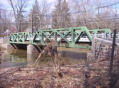
 Bridge Tender's House and bridge over the Delaware and Raritan Canal | |
| Location | Roughly Canal Road from Old Georgetown Road to Ten Mile Run |
|---|---|
| Area | 861 acres (348 ha) |
| NRHP reference No. | 84002798 [16] |
| NJRHP No. | 2496 [17] |
| Significant dates | |
| Added to NRHP | August 2, 1984 |
| Designated NJRHP | June 21, 1984 |
The Griggstown Historic District is a 861-acre (348 ha) national historic district encompassing the community along Canal Road from Old Georgetown Road to Ten Mile Run. It was added to the National Register of Historic Places on August 2, 1984 for its significance in agriculture, architecture, commerce, industry, and transportation. The district includes 68 contributing buildings. The Griggstown Reformed Church was established in 1842 as the First Reformed Protestant Dutch Church of Griggstown. The building was dedicated on August 8, 1843, and features Greek Revival architecture. The Bridge Tender's House, the Bridge Tender’s Station and the Lock Tender's House, all built for the Delaware and Raritan Canal, are contributing buildings. [18]
Notable people
People who were born in, residents of, or otherwise closely associated with Griggstown include:
- Benjamin Griggs (1690-1768), founder of the grist mill after which Griggstown took its name.
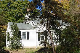
- John Honeyman (1729-1822), American spy for George Washington. He was primarily responsible for gathering the intelligence crucial to Washington's victory in the Battle of Trenton. [19]
- Paul Muldoon (born 1951) writer, academic and educator, as well as Pulitzer Prize-winning poet originally from County Armagh, Northern Ireland. [20]
Gallery
-
 Bridge Tender’s Station
 -
 Lock Tender's House
 -
 John Honeyman House
 -
 The Griggstown Causeway over the Millstone River


See also
References
- ^ a b c Gazetteer of New Jersey Places, United States Census Bureau. Accessed July 21, 2016.
- ^ a b US Gazetteer files: 2010, 2000, and 1990, United States Census Bureau. Accessed September 4, 2014.
- ^ "ArcGIS REST Services Directory". United States Census Bureau. Retrieved October 11, 2022.
- ^ a b "Griggstown Census Designated Place". Geographic Names Information System. United States Geological Survey, United States Department of the Interior.
- ^ a b Census Data Explorer: Griggstown CDP, New Jersey, United States Census Bureau. Accessed June 15, 2023.
- ^ Geographic Codes Lookup for New Jersey, Missouri Census Data Center. Accessed June 9, 2023.
- ^ State of New Jersey Census Designated Places - BVP20 - Data as of January 1, 2020, United States Census Bureau. Accessed December 1, 2022.
- ^ GCT-PH1 - Population, Housing Units, Area, and Density: 2010 - County -- County Subdivision and Place from the 2010 Census Summary File 1 for Somerset County, New Jersey Archived 2020-02-12 at archive.today, United States Census Bureau. Accessed February 11, 2013.
- ^ 2006-2010 American Community Survey Geography for New Jersey, United States Census Bureau. Accessed February 11, 2013.
- ^ New Jersey: 2010 - Population and Housing Unit Counts - 2010 Census of Population and Housing (CPH-2-32), United States Census Bureau, August 2012. Accessed February 11, 2013.
- ^ Locality Search, State of New Jersey. Accessed April 18, 2015.
- ^ a b c d e DP-1 - Profile of General Population and Housing Characteristics: 2010 Demographic Profile Data for Griggstown CDP, New Jersey Archived 2020-02-12 at archive.today, United States Census Bureau. Accessed August 28, 2012.
- ^ Shackleford, James (August 15, 2011). "The Legend of the Ghost Cow". South Brunswick, NJ Patch. Retrieved June 1, 2023.
- ^ Chirco, Vicki. The Legend of the Griggstown Cow", New Jersey Division of Parks and Forestry. Accessed June 1, 2023.
- ^ a b William B. Brahms, Franklin Township, Somerset County, NJ: A History, FTPL; ISBN 0-9668586-0-3
- ^ "National Register Information System – (#84002798)". National Register of Historic Places. National Park Service. November 2, 2013.
- ^ "New Jersey and National Registers of Historic Places – Somerset County" (PDF). New Jersey Department of Environmental Protection – Historic Preservation Office. September 28, 2021. p. 6.
- ^ Gibson, David; Bauer, Steven (September 1983). "National Register of Historic Places Inventory/Nomination: Griggstown Historic District". National Park Service. With accompanying 50 photos
- ^ History of Franklin Township, NY-NJ-CT Botany Online. Accessed September 22, 2007. "1777:... In Griggstown John Honeyman (with a home that still stands at the foot of Bunker Hill Road and Canal Road) posed as a cattle-trader sympathetic to the British in order to spy on them. Honeyman's information helped Washington plan the surprise attack on Trenton."
-
^
"Making history in Griggstown".
Princeton Packet. November 27, 2007. Retrieved July 24, 2008.
Two presentations by John Allen, president of the Griggstown Historical Society, were made. Mark Alan Hewitt, project architect, received an autographed copy of Moy Sand & Gravel by Pulitzer Prize-winning poet Paul Muldoon, a Griggstown resident.
[ permanent dead link]
External links
-
 Media related to
Griggstown, New Jersey at Wikimedia Commons
Media related to
Griggstown, New Jersey at Wikimedia Commons - "Griggstown Bridge Tender's Station". The Historical Marker Database.
Municipalities and communities of
Somerset County, New Jersey, United States | ||
|---|---|---|
| Boroughs |  | |
| Townships | ||
| CDPs |
| |
|
Other communities | ||
| Footnotes | ‡This populated place also has portions in an adjacent county or counties | |
| Topics |  | |
|---|---|---|
| Lists by county | ||
| Other lists | ||
| International | |
|---|---|
| National | |