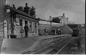
Greenmount | |
|---|---|
 | |
| General information | |
| Location |
Greenmount,
Bury England |
| Coordinates | 53°37′24″N 2°20′14″W / 53.62336°N 2.33736°W |
| Grid reference | SD778141 |
| Platforms | 1 |
| Other information | |
| Status | Disused |
| History | |
| Original company | Bury and Tottington District Railway |
| Pre-grouping | Lancashire and Yorkshire Railway |
| Post-grouping | London, Midland and Scottish Railway |
| Key dates | |
| 5 May 1882 | Station opened |
| 6 November 1952 | Station closed |
Greenmount Railway Station served the village of Greenmount in the Metropolitan Borough of Bury.
History
The Bury and Tottington District Railway opened from a junction to the north of Bury to a terminus at Holcombe Brook on 6 November 1882. Among the original stations was that at Greenmount, situated 3+1⁄4 miles (5.2 km) from Bury. [1]
The station closed when passenger services were withdrawn from the Holcombe Brook line on 5 May 1952. [2] [3]

References
- ^ Marshall, John (1970). The Lancashire & Yorkshire Railway, volume 2. Newton Abbot: David & Charles. pp. 67–68. ISBN 0-7153-4906-6.
- ^ Butt, R.V.J. (1995). The Directory of Railway Stations. Yeovil: Patrick Stephens Ltd. p. 109. ISBN 1-85260-508-1. R508.
- ^ Marshall 1970, p. 68
- Lost Railways of Lancashire by Gordon Suggitt ( ISBN 1-85306-801-2)
External links
| Preceding station | Disused railways | Following station | ||
|---|---|---|---|---|
| Holcombe Brook |
L&YR Bury to Holcombe Brook Line |
Knowles Level Crossing Halt |