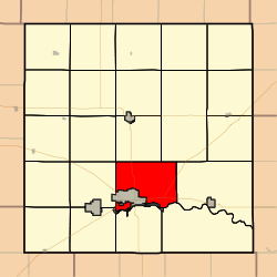
Great Bend Township | |
|---|---|
 Location in Barton County | |
| Coordinates: 38°23′27″N 098°45′22″W / 38.39083°N 98.75611°W | |
| Country | United States |
| State | Kansas |
| County | Barton |
| Area | |
| • Total | 40.46 sq mi (104.79 km2) |
| • Land | 40.25 sq mi (104.26 km2) |
| • Water | 0.2 sq mi (0.53 km2) 0.51% |
| Elevation | 1,847 ft (563 m) |
| Population (
2010) | |
| • Total | 1,752 |
| • Density | 43/sq mi (17/km2) |
| ZIP code | 67530
[1] |
| Area code | 620 |
| GNIS ID | 0475651 |
Great Bend Township is a township in Barton County, Kansas, United States. As of the 2010 census, its population was 1,752. [2]
Great Bend Township was organized in 1872. [3]
Geography
Great Bend Township covers an area of 40.46 square miles (100 km2) and contains one incorporated settlement, Great Bend (the county seat). According to the USGS, it contains two cemeteries: Golden Belt Memorial Park and Great Bend.
The stream of Dry Walnut Creek runs through this township.
Transportation
Great Bend Township contains two airports or landing strips: Button Airport and Great Bend Municipal Airport.
References
- ^ "Great Bend Township KS ZIP Code". zipdatamaps.com. 2024. Retrieved February 5, 2024.
- ^ "Profile of General Population and Housing Characteristics: 2010 Demographic Profile Data (DP-1): Great Bend township, Barton County, Kansas". United States Census Bureau. Retrieved July 13, 2012.
- ^ History of the State of Kansas: Containing a Full Account of Its Growth from an Uninhabited Territory to a Wealthy and Important State. A. T. Andreas. 1883. p. 762.
External links
