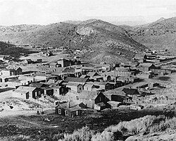
Grantsville, Nevada | |
|---|---|
 Grantsville, 1886 | |
| Coordinates: 38°50′44″N 117°34′24″W / 38.84556°N 117.57333°W [1] | |
| Country | United States |
| State | Nevada |
| County | Nye |
| Named for | Ulysses S. Grant |
| Elevation | 7,024 ft (2,141 m) |
| Time zone | UTC-8 ( Pacific) |
| • Summer ( DST) | UTC-7 ( PDT) |
Grantsville is a former town in Nye County, Nevada. [2]
The camp was started in 1863 [3] or 1864, [4] along with the nearby Union and North Union mining districts. [4] The camp was named by Unionists to honor Ulysses S. Grant. [4] In 1864, miners in the district successfully petitioned to have Nye County separated from Esmeralda County, Nevada. [3]
The Grantsville post office was in operation from February 1879 until October 1901. [5]
The Alexander and McMahon mines were in operation in the area in 1880 and 1881. [4] In 1877 the Alexander Co. built a 20-stamp mill, which was enlarged to 40 stamps in 1880. [3]
References
- ^ a b U.S. Geological Survey Geographic Names Information System: Grantsville
- ^ Frenchu, Bob; Ramirez, Luis (2004). "Grantsville". Forgotten Nevada. Bob Frenchu and Luis Ramirez. Retrieved April 28, 2020.
- ^ a b c Lincoln, Francis Church (1923). "Mining districts and mineral resources of Nevada". p. 196. hdl: 2027/mdp.39015011432807. Retrieved April 28, 2020.
- ^ a b c d Carlson, Helen S. (1985). Nevada Place Names: A Geographical Dictionary. University of Nevada Press. ISBN 978-0-87417-094-8. Retrieved April 28, 2020.
- ^ U.S. Geological Survey Geographic Names Information System: Grantsville Post Office (historical)
External links
- Grantsville - modern photos and text (forgottennevada.org)
- Grantsville - modern photos and text (ghosttowns.com)
- Grantsville - modern photos and text (nvexpeditions.com)
- Grantsville - historic photos ( University of Nevada, Reno)

