Grabownica Starzeńska | |
|---|---|
Village | |
d.jpg) Grabownica Starzeńska | |
 Grabownica Starzeńska | |
| Coordinates: 49°40′N 22°5′E / 49.667°N 22.083°E | |
| Country | |
| Voivodeship | Subcarpathian |
| County | Brzozów |
| Gmina | Brzozów |
| Population | 3,000 |
Grabownica Starzeńska [ɡrabɔvˈɲit͡sa staˈʐɛɲska] is a village in the administrative district of Gmina Brzozów, within Brzozów County, Subcarpathian Voivodeship, in south-eastern Poland. It lies approximately 6 kilometres (4 mi) south-east of Brzozów and 42 km (26 mi) south of the regional capital Rzeszów. [1]
Gallery
-
 Grabownica
 -
 Grabownica
 -
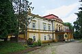 Ostaszewski Palace
 -
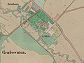 A map from 1852


e.jpg)

References
| Town and seat |  | |
|---|---|---|
| Villages | ||
|
| This Brzozów County location article is a stub. You can help Wikipedia by expanding it. |