Gournay-sur-Aronde | |
|---|---|
 The funerary monument of Madame Jarry de Mancy | |
 Gournay-sur-Aronde  Gournay-sur-Aronde | |
| Coordinates: 49°29′36″N 2°40′30″E / 49.4933°N 2.675°E | |
| Country | France |
| Region | Hauts-de-France |
| Department | Oise |
| Arrondissement | Compiègne |
| Canton | Estrées-Saint-Denis |
| Intercommunality | Pays des Sources |
| Government | |
| • Mayor (2020–2026) | Daniel Forget [1] |
| Area 1 | 14.71 km2 (5.68 sq mi) |
| Population (2021)
[2] | 537 |
| • Density | 37/km2 (95/sq mi) |
| Time zone | UTC+01:00 ( CET) |
| • Summer ( DST) | UTC+02:00 ( CEST) |
| INSEE/Postal code |
60281 /60190 |
| Elevation | 47–127 m (154–417 ft) (avg. 76 m or 249 ft) |
| 1 French Land Register data, which excludes lakes, ponds, glaciers > 1 km2 (0.386 sq mi or 247 acres) and river estuaries. | |
Gournay-sur-Aronde (French pronunciation: [ɡuʁnɛ syʁ aʁɔ̃d]) is a commune in the Oise department in northern France.
Gournay-sur-Aronde is best known for a Late Iron Age sanctuary that dates back to the 4th century BCE, and was burned and levelled at the end of the 1st century BCE. In the 4th century AD a Gallo-Roman temple was built on the site.
Gallery
-
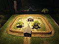 Model of the Celtic sanctuary of Gournay-sur-Aronde, 4th century BC
 -
 Model and information panel, Archéosite d'Aubechies


See also
References
- ^ "Répertoire national des élus: les maires". data.gouv.fr, Plateforme ouverte des données publiques françaises (in French). 2 December 2020.
- ^ "Populations légales 2021". The National Institute of Statistics and Economic Studies. 28 December 2023.
Wikimedia Commons has media related to
Gournay-sur-Aronde.
| International | |
|---|---|
| National | |
| Geographic | |
|
| This Oise geographical article is a stub. You can help Wikipedia by expanding it. |