Gornje Selo | |
|---|---|
Village | |
| Country | |
| Area | |
| • Total | 5.6 sq mi (14.6 km2) |
| Population (2021)
[2] | |
| • Total | 262 |
| • Density | 46/sq mi (18/km2) |
| Time zone | UTC+1 ( CET) |
| • Summer ( DST) | UTC+2 ( CEST) |
Gornje Selo, ( Italian: Villa Superior), the "Upper village" is a village and a cadastral in Croatia on the island of Šolta in the Split-Dalmatia County. It is connected by the D111 highway. Gornje Selo village in the interior of the island largely without tourism. The population engaged in farming, or are fishermen or seamen. At the beginning of the town there is a modern olive oil mill. To place unspoiled bays are on the south coast and east coast of the island.
During the time of the Austro-Hungarian Empire the villages of Šolta still have their Italian names as well as Villa Superior. [3]
Image gallery
- Gornje Selo
-
 Monument to the World War II victims
 -
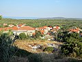
 View to the northwest
 -
 View to the south
 -
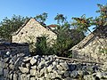 Dilapidated barns
 -
 Modern olive oil mill


43°21′11″N 16°20′28″E / 43.35306°N 16.34111°E
External links
- Šolta Island Tourist Board. "Šolta. The Return to Innocence". Grohote. Retrieved 2019-09-05.
References
- ^ Register of spatial units of the State Geodetic Administration of the Republic of Croatia. Wikidata Q119585703.
- ^ "Population by Age and Sex, by Settlements, 2021 Census". Census of Population, Households and Dwellings in 2021. Zagreb: Croatian Bureau of Statistics. 2022.
- ^ Stermich (Segretaria di Governo) (1841-02-02). "AVVISO Nr. 24979-9466". Gazzetta di Zara / Gazzetta di Zara. Foglio Ufficiale (d’Annuncii/d’Annuzi) della Gazzetta di Zara (in Italian). Zadar: ANNO. p. 12. Retrieved 2019-09-04. (Price list for cadastral extracts)
|
| This Split-Dalmatia County geography article is a stub. You can help Wikipedia by expanding it. |