Glad Valley, South Dakota | |
|---|---|
 Glad Valley, South Dakota | |
| Coordinates: 45°23′57″N 101°46′40″W / 45.39917°N 101.77778°W | |
| Country | United States |
| State | South Dakota |
| County | Ziebach |
| Elevation | 2,464 ft (751 m) |
| Time zone | UTC-6 ( Central (CST)) |
| • Summer ( DST) | UTC-5 |
| Area code | 605 |
| GNIS feature ID | 1255253 [1] |
Glad Valley is an unincorporated community in Ziebach County, South Dakota, United States. Glad Valley is located on South Dakota Highway 20, 17 miles (27 km) west of Isabel.
Glad Valley was laid out in 1926, and named for the nearby Glad Valley Ranch. [2]
References
- ^ a b U.S. Geological Survey Geographic Names Information System: Glad Valley, South Dakota
- ^ Federal Writers' Project (1940). South Dakota place-names, v.1-3. University of South Dakota. p. 38.
Municipalities and communities of
Ziebach County, South Dakota, United States | ||
|---|---|---|
| Cities | 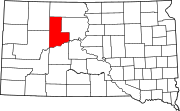 | |
|
Unorganized territories | ||
| CDPs | ||
|
Other communities | ||
| Indian reservations | ||
| Footnotes | ‡This populated place also has portions in an adjacent county or counties | |
|
| This South Dakota state location article is a stub. You can help Wikipedia by expanding it. |