| Gap of Dunloe | |
|---|---|
| Dún Lóich | |
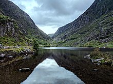
 At the Black Lake in the Gap of Dunloe, looking south towards the Head of the Gap | |
| Elevation | 241 metres (791 feet) [1] |
| Traversed by | Public Road [2] |
| Location | County Kerry, Ireland |
| Range | |
| Coordinates | 52°1′00″N 9°38′7.8″W / 52.01667°N 9.635500°W |
| Topo map | OSI Discovery 78 |
 Location in Ireland | |
The Gap of Dunloe (from Irish Dún Lóich, meaning "Lóich's stronghold"), also recorded as Bearna an Choimín (meaning "gap of the commonage" or "gap of the little hollow"), [3] is a narrow mountain pass running north–south in County Kerry, Ireland, that separates the MacGillycuddy's Reeks mountain range in the west, from the Purple Mountain Group range in the east. It is one of Kerry's most popular tourist destinations on account of its scenery. [4]
Naming

The term "Dunloe" is believed to be an anglicisation of the Irish term "Dún Lóich", meaning fort or stronghold of Lóich (the River Loe that runs through the Gap of Dunloe valley also derives its name from the same source). [5] According to the Annals of Clonmacnois, Keating and the Lebor Gabála Érenn (LGE), Deala (or Dela) Mac Lóich was the father of the five chieftains of the returning Fir Bolg (Slainghe, Gann, Genann, Seangann, and Rudhraighe), who conquered Ireland and divided it into five provinces, each ruled by one brother. [6] According to the Annals of the Four Masters, the Fir Bolg ruled Ireland for 37 years from 3266 to 3303 BCE, [7] but were themselves defeated by the returning Tuatha Dé Danann. [5]
Geography
_Gap_of_Dunloe.jpg)
The Gap of Dunloe was formed 25,000 years ago during Ireland's last ice age as a result of a "glacial breach" where a glacier in the Black Valley, part of the Templenoe Icecap, estimated to be over 500 metres deep, broke through the Head of the Gap and moved northwards carving out a U-shaped valley. [8] [9] [10]
The pass runs north–south between the Old Red Sandstone mountain ranges of the MacGillycuddy's Reeks (to the west) and the Purple Mountain Group (to the east). The north–south road through The Gap as the area is also known, goes from Kate Kearney's Cottage in the north, to the highest point at the Head of the Gap at 241 metres (791 feet), [1] and down to Lord Brandon's Cottage in the Black Valley in the south. The road from Kate Kearney's Cottage to Lord Brandon's Cottage is 11 kilometres (7 miles) in length, with 200 metres (650 feet) in total elevation change. [1]
Within The Gap are five lakes (from north to south): Coosaun Lough, Black Lake, Cushnavally Lake, Auger Lake, and Black Lough. The lakes are connected by the River Loe. Between the first two, Coosaun Lough and Black Lake is the Wishing Bridge on which it is said that wishes made while upon it are destined to come true. [11] [12] The stone bridge at the northern end of Augher Lake and the stone bridge at the northern end of Black Lough are also lookout points.
Access
.jpg)
The road through the Gap of Dunloe, from Kate Kearney's Cottage in the north, into the Black Valley in the south, is a public road, [2] and under the charge of Kerry County Council. [15] In 2005, private jaunting car operators were accused of preventing tourists from driving the road. [16] Lonely Planet clarified that the road is public in its 2018 Ireland guidebook. [13] [14]
.jpg)
The true Head of the Gap (at V872838), can be accessed from the north by driving past Kate Kearney's Cottage, and from the south by driving to Moll's Gap and then continuing east on the R568 road until a small side-road (at V853774, sometimes labelled "Gearhasallagh" after the townsland, on maps), descends steeply north into the Black Valley and then winds its way westwards towards Lord Brandon's Cottage (which is off-route), but then diverts north to the actual Head of the Gap; this route is part of a 55–kilometre loop of the Killarney–Gap of Dunloe–Black Valley–Moll's Gap area, [17] [18] popular with cyclists. [19]
As the public road through the Gap of Dunloe road reaches the Head of the Gap it becomes narrow and winding and is difficult for vehicles to pass, which has led to concerns over safety; there have been fatalities over the years of cyclists. [2] [15] There have also been fatalities of tourists in jaunting cars. [20]
Climbing and walking
Hill walking
The mountain ranges on either side of The Gap ( MacGillycuddy's Reeks to the west, and Purple Mountain Group to the east), are common hill walking routes (some routes are discussed in more detail in their respective articles). The walk from Kate Kearney's Cottage (at V872838), to the full Head of the Gap (at V872838) is 6 kilometres and takes circa 1 hour (and another hour for the return journey back to Kate Kearney's Cottage). [4] [21]
Rock climbing

While not as well known as other Irish rock climbing locations (like Ailladie, Fair Head or Dalkey Quarry), various Old Red Sandstone cliffs and crags along the Gap of Dunloe are used as locations for rock climbing, and over 107 routes are listed and graded in the Irish Climbing Online Wiki. [22] [23] [24]
There are only two crags on the east side of the valley, namely Céim and Bothán, with most of the crags being in the north-west side of the valley, near Brennan's Leap (the cliff at the western shore of Coosaun Lough) / the Wishing Bridge (the stone bridge between Coosaun Lough and Black Lake). [25] Grades range from V–Diff to E5 6b (Far Away Friends 10 m E5 6b, Cub Crag), with The Main Face crag having some of the longest +30 metre higher E–grade climbs (including Demasiado 40 m E1 5b, 5a), [25] and Jigzaw Wall having short but also some of the hardest climbs in the valley. [26]
The Gap was ranked as one of the "top 5 areas" for bouldering in Ireland, [27] including The Main Face crag, with grades of up to 7b. [28]
Climbing bibliography
Hill walking:
- Fairbairn, Helen (2014). Ireland's Best Walks: A Walking Guide. Collins Press. ISBN 978-1848892118.
- MountainViews (Simon Stewart) (2013). A Guide to Ireland's Mountain Summits: The Vandeleur-Lynams & the Arderins. Collins Books. ISBN 978-1-84889-164-7.
- Ryan, Jim (2006). Carrauntoohil and MacGillycuddy's Reeks: A Walking Guide to Ireland's Highest Mountains. Collins Press. ISBN 978-1905172337.
- Dillion, Paddy (1993). The Mountains of Ireland: A Guide to Walking the Summits. Cicerone. ISBN 978-1852841102.
Rock climbing:
- Richard, Creagh; Richard, Stack (25 January 2014). Gap of Dunloe Rock Climbing Guide (PDF).
- Flanagan, David (2014). Rock Climbing in Ireland. Three Rock Books. ISBN 978-0956787422.
Gallery
-
 At the Head of the Gap (highest point) looking northwards
 -
 Looking southwards across Augher Lake up into the Head of the Gap
 -
 Looking northwards at the road down to Augher Lake
 -
 Looking southwards across Augher Lake up into the Head of the Gap
 -
 Looking northwards to the stone bridge before Black Lough


_Gap_of_Dunloe.jpg)
.jpg)
See also
- Ailladie, major rock climbing limestone sea-cliff in County Clare
- Fair Head, major rock climbing dolerite mountain crag in County Antrim
- Dalkey Quarry, major rock climbing granite quarry in Dublin
- Purple Mountain Group, mountain range to the east of The Gap
- MacGillycuddy's Reeks, mountain range to the west of The Gap
References
- ^ a b c Graham Robb (July 2016). Cols and Passes of the British Isles. Penguin UK. ISBN 978-1846148736.
- ^
a
b
c Anne Lucey (15 June 2017).
"Cyclist's widower: Beef up road safety at Gap of Dunloe".
Irish Examiner.
The Gap, a public road through the MacGillycuddy's Reeks, is one of the most visited tourist routes in Ireland, famous since Victorian times.
-
^
"Bearna an Choimín". Loganim. Retrieved 13 December 2018.
bearna (freisin: bearn, bearnaidh) gap : coimín commonage, common land; little hollow, glen
- ^
a
b Tony Doherty (1 May 2010).
"Cracker of a Kerry walk".
Irish Times.
THE GAP OF DUNLOE, in Co Kerry, is a feature of most tourist brochures of Ireland. Its string of ribbon lakes overlooked by steep cliffs makes it an essential part of a visit to the southwest.
- ^ a b Koch, John T. Celtic Culture: A Historical Encyclopedia. ABC-CLIO, 2006. pp.749-750
-
^
"Firbolgs". LibraryIreland. Retrieved 13 December 2018.
An Illustrated History of Ireland, by Margaret Anne Cusack
-
^ Hugh McGough.
"Pre-Milesian Irish Kings". Retrieved 13 December 2018.
According to the Annals of the Four Master, the Firbolgs rules Ireland for 37 years, from the "age of the world" 3266 to 3303. [..] The Firbolg descend from northern Gaul. While they were once termed 'Men of the Bags' after 'bolg' it is now thought they were named for their deity Bolg or Bolga. During the 37 year reign of the Firbolgs, their king Eochaid was known as a just and generous monarch.
-
^ John Crowley; John Sheehan (May 2009).
The Iveragh Peninsula: A Cultural Atlas of the Ring of Kerry.
University College Cork.
ISBN
9781859184301.
The Physical Landscape of the Iveragh Peninsula
-
^
"Wondrous ways of the MacGillycuddy's Reeks".
Irish Examiner. 28 November 2016.
In an introduction, UCC academics John Crowley and John Sheehan relate the history of the Reeks, informing us glaciers gouged out spectacular breaches in the mountains like the Gap of Dunloe and Moll's Gap, about 25,000 years ago.
- ^ "Killarney Valley Geology Trail" (PDF). KillarneyNationalPark.ie. Retrieved 15 September 2018.
-
^ Donnacha Clifford; David Elton (7 September 2017).
"Cycling through one of the most scenic and secluded parts of Kerry".
Irish Times.
The initial ascent leads up to a bridge in between the first two lakes of the day. This bridge is known as the Wishing Bridge and wishes made on it are supposed to come true.
- ^ Anne Lucey (10 April 2018). "Two US tourists die in jaunting car accident at the Wishing Bridge". Irish Examiner.
- ^
a
b
"Gap of Dunloe, Ireland: Essential information (2018)".
Lonely Planet. Archived from
the original on 14 December 2018. Retrieved 13 December 2018.
Despite a road sign at Kate Kearney's Cottage implying that cars are forbidden, it is perfectly legal to drive through the Gap of Dunloe – it's a public road.
- ^ a b Neil Wilson (9 March 2018). Lonely Planet Ireland (2018 Travel Guide). Lonely Planet. ISBN 978-1786574459.
- ^
a
b
"Coroner recommends Gap of Dunloe warning signs after cyclist's death".
RTE News. 3 August 2018.
The coroner and the jury have recommended there be warning signs on the busy regional road which is under the charge of Kerry County Council.
-
^
"Claims of tourists being prevented from driving around the Gap Of Dunloe".
Radio Kerry. 29 June 2015.
A B&B owner in Caherciveen is claiming that poneymen are stopping tourists from driving around the Gap of Dunloe. It's understood that a group of Dutch tourists were told to turn back by the ponymen. A spokesperson for the poneymen rejects the allegation. Kerry County Council says the road through the Gap of Dunloe is a public roadway and the public have right of way at all times. The Council says the ponymen have no authority to stop people driving through.
- ^ Dan MacCarthy (3 May 2017). "Summer cycles: Two new books to guide you on your journeys". Irish Examiner.
- ^ "MOLLS GAP, GAP OF DUNLOE, BLACK VALLEY LOOP". Mapmyride.com. 11 May 2012.
- ^ "Gap of Dunloe-Black Valley-Molls Gap-Killarney Loop". Bikemap.net. Retrieved 13 December 2018.
-
^ Barry Roche (9 April 2018).
"Two killed in 'freak' pony and trap accident in Killarney".
Irish Times.
An American couple in their 60s travelling in a pony and trap were flung down a 12ft ravine on to rocks when the horse bolted in the Gap of Dunloe in Co Kerry on Monday.
-
^
"Purple Mountain". Munster Hill Walks. Retrieved 14 December 2018.
From Kate Kearney's Cottage GR(V 88.09 88.78) proceed into the gap of Dunloe in a southerly direction, as you walk along the road you will pass by Black Lake, Cushnavally Lake and Auger Lake and Black Lough. This road is often busy with hill walkers and in the summer months you will frequently encounter Jarvey horse and carts as they carry visitors through the gap. As you rise out of the gap of Dunloe you reach your first major waypoint at Head of Gap GR(V 87.15 83.71). This section of the walk is about 5km and takes about an hour but time seems to pass much quicker.
- ^ "Gap of Dunloe". Irish Climbing Online Wiki. Retrieved 13 December 2018.
- ^ "Gap of Dunloe". UKClimbing.com. Retrieved 13 December 2018.
- ^ David Flanagan. "Gap of Dunloe (Extract from "Rock climbing in Ireland")" (PDF). Three Rock Books. ISBN 978-0956787422.
- ^ a b Richard Creagh (May 2011). "Gap of Dunloe Rock Climbing Guide" (PDF).
- ^ "The Gap of Dunloe: An Introduction to the Kingdom of Climbing". Outsider.ie. January 2018.
-
^
"The Top 5 Areas for Bouldering in Ireland". Outsider.ie. January 2012.
5. Gap of Dunloe and Black Valley, County Kerry. The Gap of Dunloe splits the MacGillycuddy's Reeks, Ireland's highest mountains. A small road, with boulders scattered on either side, winds its way through the Gap and down into the Black Valley. The rocks are purple sandstone with great friction and many slopers and pockets, and only a handful have been developed, so there are plenty of new problems to climb. The steep walls of the Gap mean that even in the summer cool conditions can be found in the evenings.
- ^ David Flanagan (January 2009). "Gap of Dunloe: Bouldering Guide" (PDF).
External links
- IrishClimbingOnlineWiki.ie Ailladie Online Database
- UKClimbing.com Gap of Dunloe Online Database
- Motorbike-Cam through The Gap, a 13-minute journey from the Head of the Gap in the south to Kate Kearney's Cottage
| International | |
|---|---|
| National | |