This article needs additional citations for
verification. (May 2021) |
| Gandaulim Fort | |
|---|---|
| Part of Goa | |
| Ilhas de Goa, India | |
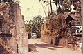
 Gandaulim Fort Entrance Gate in the 1990s | |
 Location of São Braz in
Ilhas de Goa | |
 Gandaulim Fort  Gandaulim Fort | |
| Coordinates | 15°30′50″N 73°56′37″E / 15.513819°N 73.943577°E |
| Type | Fort |
| Height | 20 m |
| Site information | |
| Owner | Government of Goa |
| Controlled by | |
| Open to the public | Yes |
| Condition | Abandoned Ruins |
| Site history | |
| Built | 1537 |
| Materials | Laterite stones and mud |
| Demolished | Yes |
| Battles/wars | unknown |
| Events | Demolished in the 2000s |
| Garrison information | |
| Current commander | n/a |
| Garrison | n/a |
| Occupants | none |
The Gandaulim Fort, also called the Gaudelupchar Fort was a military installation built on the eastern tip of the Ilhas de Goa. It is believed to date from the 16th-century. The fortress was allegedly built to defend the settlement of São Braz ( lit. 'St. Blaise'). It also housed a chapel dedicated to St. Blaise, which later was elevated into a church in 1563.
Demolition
By the advent of the 21st century, the only remaining evidence of the fort consisted of its entrance gate and a few rundown walls. The gate was demolished by the government authorities, as part of a road expansion project, to widen the approach road to the Gandaulim-Cumbarjua ferry. [1]
Gallery
-
 Gandaulim Fort Entrance Gate after Demolition
 -
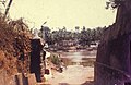 Gandaulim Fort Entrance Gate post Demolition


See also
References
- ^ "Why this Goan village will root for Croatia". The times of India.