Gamagōri
蒲郡市 | |
|---|---|
 | |
 Flag  Seal | |
|
| |
 Location of Gamagōri in Aichi Prefecture | |
 Gamagōri | |
| Coordinates: 34°50′35″N 137°13′10.5″E / 34.84306°N 137.219583°E | |
| Country | Japan |
| Region | Chūbu ( Tōkai) |
| Prefecture | Aichi |
| Government | |
| • Mayor | Hisaaki Suzuki |
| Area | |
| • Total | 56.92 km2 (21.98 sq mi) |
| Population (October 1, 2019) | |
| • Total | 80,063 |
| • Density | 1,400/km2 (3,600/sq mi) |
| Time zone | UTC+9 ( Japan Standard Time) |
| Phone number | 0533-66-1111 |
| Address | 17-1 Asahi-chō, Gamagōri-shi, Aichi-ken 443-8601 |
| Climate | Cfa |
| Website | Official website |
| Symbols | |
| Flower | Azalea |
| Tree | Camphor Laurel |
Gamagōri (蒲郡市, Gamagōri-shi) is a city in Aichi Prefecture, Japan. As of 1 October 2019 [update], the city had an estimated population of 80,063 in 32,800 households, [1] and a population density of 1,407 persons per km2. The total area of the city is 56.92 square kilometres (21.98 sq mi).
Geography
_11.jpg)
Gamagōri is situated on the coast of Mikawa Bay on the Pacific Ocean in southeastern Aichi Prefecture. Sheltered by Chita Peninsula and Atsumi Peninsula, the climate is mild, and parts of the city is within the borders of the Mikawa Wan Quasi-National Park.
Climate
The city has a climate characterized by hot and humid summers, and relatively mild winters ( Köppen climate classification Cfa). The average annual temperature in Gamagōri is 16.3 °C (61.3 °F). The average annual rainfall is 1,631.2 mm (64.22 in) with September as the wettest month. The temperatures are highest on average in August, at around 27.4 °C (81.3 °F), and lowest in January, at around 5.6 °C (42.1 °F). [2]
| Climate data for Gamagōri (1991−2020 normals, extremes 1979−present) | |||||||||||||
|---|---|---|---|---|---|---|---|---|---|---|---|---|---|
| Month | Jan | Feb | Mar | Apr | May | Jun | Jul | Aug | Sep | Oct | Nov | Dec | Year |
| Record high °C (°F) | 18.4 (65.1) |
21.4 (70.5) |
24.8 (76.6) |
29.7 (85.5) |
32.8 (91.0) |
35.4 (95.7) |
38.4 (101.1) |
38.7 (101.7) |
37.2 (99.0) |
32.2 (90.0) |
25.3 (77.5) |
23.0 (73.4) |
38.7 (101.7) |
| Mean daily maximum °C (°F) | 9.9 (49.8) |
10.9 (51.6) |
14.4 (57.9) |
19.5 (67.1) |
23.9 (75.0) |
26.6 (79.9) |
30.5 (86.9) |
32.3 (90.1) |
28.8 (83.8) |
23.4 (74.1) |
17.9 (64.2) |
12.4 (54.3) |
20.9 (69.6) |
| Daily mean °C (°F) | 5.6 (42.1) |
6.2 (43.2) |
9.4 (48.9) |
14.5 (58.1) |
18.9 (66.0) |
22.2 (72.0) |
26.1 (79.0) |
27.4 (81.3) |
24.2 (75.6) |
18.9 (66.0) |
13.4 (56.1) |
8.1 (46.6) |
16.2 (61.2) |
| Mean daily minimum °C (°F) | 1.9 (35.4) |
2.1 (35.8) |
5.0 (41.0) |
10.1 (50.2) |
14.9 (58.8) |
18.8 (65.8) |
22.9 (73.2) |
24.0 (75.2) |
20.8 (69.4) |
15.3 (59.5) |
9.6 (49.3) |
4.4 (39.9) |
12.5 (54.5) |
| Record low °C (°F) | −5.5 (22.1) |
−6.0 (21.2) |
−1.8 (28.8) |
1.1 (34.0) |
6.0 (42.8) |
12.8 (55.0) |
16.5 (61.7) |
17.9 (64.2) |
12.5 (54.5) |
6.1 (43.0) |
1.2 (34.2) |
−2.7 (27.1) |
−6.0 (21.2) |
| Average precipitation mm (inches) | 58.8 (2.31) |
67.0 (2.64) |
128.1 (5.04) |
139.3 (5.48) |
160.9 (6.33) |
193.3 (7.61) |
193.6 (7.62) |
124.5 (4.90) |
230.7 (9.08) |
187.6 (7.39) |
90.0 (3.54) |
57.4 (2.26) |
1,631.2 (64.22) |
| Average precipitation days (≥ 1.0 mm) | 5.7 | 6.3 | 9.4 | 9.6 | 9.9 | 12.0 | 11.0 | 7.4 | 10.7 | 10.2 | 6.5 | 6.2 | 104.9 |
| Mean monthly sunshine hours | 181.0 | 175.8 | 201.3 | 204.7 | 212.7 | 152.3 | 181.8 | 223.2 | 168.4 | 169.4 | 168.0 | 179.8 | 2,218.5 |
| Source: Japan Meteorological Agency [3] [2] | |||||||||||||
Demographics
Per Japanese census data, [4] the population of Gamagōri has been relatively steady over the past 30 years.
| Year | Pop. | ±% |
|---|---|---|
| 1950 | 63,923 | — |
| 1960 | 75,723 | +18.5% |
| 1970 | 82,868 | +9.4% |
| 1980 | 85,295 | +2.9% |
| 1990 | 84,819 | −0.6% |
| 2000 | 82,108 | −3.2% |
| 2010 | 82,222 | +0.1% |
Neighboring municipalities
History
Ancient history
Records of place names in present-day Gamagōri have been found from the Nara period.
The area was divided into several shōen during the Heian period, largely under the control of the Udono clan.
Early modern period
During the Edo period, most of the area was tenryō territory ruled directly by the Tokugawa shogunate through hatamoto administrators, with portions controlled by Yoshida Domain and Okazaki Domain.
Late modern period
After the start of the Meiji period, Gamagōri Village in Hoi District, Aichi Prefecture was proclaimed on October 1, 1889. Gamagōri was elevated to town status on October 6, 1891.
The area of the town expanded through annexation of the neighboring villages of Toyooka, Kaminogo and Shizusato on July 4, 1906.
The town escaped damage in World War II, but the 1945 Mikawa earthquake caused considerable damage to parts of Gamagōri.
Contemporary history
The city of Gamagōri was proclaimed on April 1, 1954, when the town of Gamagōri merged with the neighboring town of Miya and village of Shiotsu.
The village of Otsuka joined Gamagōri on October 1, 1956, followed by Katahara on April 1, 1962, and Nishiura on April 1, 1963.
Government
_07.jpg)
Gamagōri has a mayor-council form of government with a directly elected mayor and a unicameral city legislature of 20 members. The city contributes one member to the Aichi Prefectural Assembly. In terms of national politics, the city is part of Aichi District 14 of the lower house of the Diet of Japan.
Economy
Gamagōri is a regional commercial center and fishing port, with a mixed economy of light manufacturing and agriculture. Gamagōri is also noted for its production of hothouse oranges. Companies headquartered in the city include:
- Nidek Co., Ltd., optics
- Japan Tissue Engineering Co., Ltd., bio-pharmaceuticals
- Takemoto Oil & Fat Co. Ltd., edible oils
- Gamasa Food Co. Ltd., food processing
- Nippon Tokushu Goukin Co., Ltd., metal fittings and components
Education
.jpg)
University
Junior college
Schools
- Gamagōri has 13 public elementary schools and seven public middle schools operated by the city government and two public high schools operated by the Aichi Prefectural Board of Education. There is also one private high school.
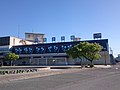
Transportation
_03.jpg)
Railways
Conventional lines
Roads
Expressways
Japan National Route
External relations
Twin towns – Sister cities
National
-
 Urasoe (
Okinawa Prefecture
Kyushu Region)
Urasoe (
Okinawa Prefecture
Kyushu Region)
- since November 4, 1981
Sister port
International
-
 Gisborne (
New Zealand
Gisborne Region)
Gisborne (
New Zealand
Gisborne Region)
- since July 27, 1996 [5]
Local attractions
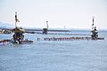
As part of Mikawa Wan Quasi-National Park with numerous scenic offshore islands, Gamagōri is noted for marine sports. There are also several hot spring resorts within the city limits. The Gamagōri Matsuri, held in late July features a fireworks display, and the local festival of former Miya village held in October features an event where mikoshi are carried into the sea. The city is also home to the Lagunasia amusement park and Spa Nishiura Motor Park racetrack.
The small fishing community of Nishiura is noted for its onsen (hot spring resorts), some of which are located near its beach front. The area is famous for the medicinal properties of its water and a number of hotels have sprung up to accommodate the tourists visiting these spas.
-
 Nishiura Onsen
 -
 Miya festival
 -
 Laguna Ten Bosch
 -
 Takeshima Aquarium
 -
 Gamagori Classic Hotel
 -
 Katahara Onsen (Hydrangea Park)
 -
 Katahara Onsen (Hydrangea Park)


_02.jpg)
_08.jpg)


Notable people from Gamagōri
- Suzuki Mosaburō, politician
- Keiichiro Hirano, Akutagawa-prize winning novelist
- Tamanoumi Masahiro, sumo wrestler
- Sakae Ōba, Captain of 18th Infantry Regiment
- Kodai Senga, Pitcher for the New York Mets and Japan National Baseball Team [6]
References
- ^ Gamagōri City official statistics (in Japanese)
- ^ a b 気象庁 / 平年値(年・月ごとの値). JMA. Retrieved April 13, 2022.
- ^ 観測史上1~10位の値(年間を通じての値). JMA. Retrieved April 13, 2022.
- ^ Gamagōri population statistics
- ^ "Sister Cities". Gisbourne official home page. Retrieved 29 December 2015.
- ^ "ソフトバンク千賀、地元蒲郡市スポーツ栄誉賞を受賞 - 野球 : 日刊スポーツ".
External links
- Official website (in Japanese)
 Geographic data related to
Gamagōri at
OpenStreetMap
Geographic data related to
Gamagōri at
OpenStreetMap
| Nagoya |
| |||
|---|---|---|---|---|
| Core cities | ||||
| Special city | ||||
| Cities | ||||
| Districts | ||||
| Former Districts | ||||
| International | |
|---|---|
| National | |
| Geographic | |