

The Galilee panhandle ( Hebrew: אצבע הגליל, Etzba HaGalil (lit. "Finger of the Galilee"), is an elongated geopolitical area or " panhandle" in northern Israel comprising the northernmost section of the Upper Galilee, and the northern Jordan Rift Valley. The Galilee Panhandle incorporates five municipal authorities. [1] Towns in the Galilee panhandle include Metula and Kiryat Shmona.
The ancient site of Tel Dan is located in the Galilean panhandle.
Geography
The Galilee panhandle is a narrow strip of land running from the Israel-Lebanon border in the far north to an imaginary line below the Hula Valley, approximately between the kibbutzim Malkia and Gonen, in the south.[ citation needed]
-
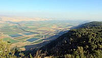 View from Manara cliff
 -
 View of Kiryat Shmona from Mitzpe Liran


History
In 1920, the Sykes-Picot Treaty was amended to transfer areas of Jewish settlement from the territory of the French Mandate for Syria and the Lebanon to that of the British Mandate for Palestine. [2] From April 1924, the area came under British control. [3] An agreement was reached which enabled cultivation on both sides of the border with taxes being distributed between the British and French mandate authorities. [4] The boundary was problematic, strategically and politically, but harnessing water sources in this region was vital for the development of the country. [5]
During Operation Yiftah in April and May 1948, the Arabs living in the Galilee panhandle and the other Shia villages in Palestine were expelled by Palmach forces. [6] [7]
Cross-border raiding [8] and rocket attacks from Lebanon have been an ongoing problem for communities in the Galilee panhandle [9] In November 2011, rockets were fired into Israel, landing near the border. The incident was called "a dangerous reminder" of the 34-day war in 2006 against Iranian- and Syrian-backed Hezbollah forces in Lebanon. [10]
See also
- Geography of Israel
- Good Fence, an epithet for Israel's mountainous 80-mile northern border with Lebanon after the 1978 South Lebanon conflict
- Upper Galilee Regional Council
References
- ^ The Sources of the Jordan River, Humans and Nature
- ^ "N. Blanford, The Seven Villages: Origins and Implications" (PDF). Archived from the original (PDF) on 2014-01-08. Retrieved 2017-04-19.
- ^ An Empire in the Holy Land: Historical Geography of the British Administration in Palestine, 1917–1929, Gideon Biger, St. Martin's Press, New York, 1994, p. 181.
- ^ An Empire in the Holy Land: Historical Geography of the British Administration in Palestine, 1917–1929, Gideon Biger, St. Martin's Press, New York, 1994, p. 58
- ^ An Empire in the Holy Land: Historical Geography of the British Administration in Palestine, 1917–1929, Gideon Biger, St. Martin's Press, New York, 1994, p. 274
- ^ Benny Morris, 1948: A History of the First Arab-Israeli War, Yale University Press, 2008, p. 161.
- ^ Benny Morris, The Birth of the Palestinian Refugee Problem Revisited, Cambridge University Press, 2004, pp. 249– 252.
- ^ "Peace Building Academy: Lebanon conflict briefing". Archived from the original on 2012-09-11. Retrieved 2012-01-27.
- ^ Rocket hits Galilee panhandle
- ^ Israel claims rocket attack from Lebanon
External links
-
 Media related to
Galilee Panhandle at Wikimedia Commons
Media related to
Galilee Panhandle at Wikimedia Commons
.svg)