This article includes a
list of references,
related reading, or
external links, but its sources remain unclear because it lacks
inline citations. (March 2016) |
| Fort DuPont State Park | |
|---|---|
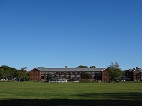
 Parade grounds at Fort DuPont | |
| Location | New Castle, Delaware, United States |
| Coordinates | 39°34′17″N 75°35′01″W / 39.57139°N 75.58361°W |
| Area | 322 acres (130 ha) |
| Elevation | 3 ft (0.91 m) |
| Established | 1992 |
| Named for | Fort DuPont, which is named for Samuel Francis duPont |
| Governing body | Delaware Department of Natural Resources and Environmental Control |
| Website | Fort DuPont State Park |
Fort DuPont State Park is a Delaware state park located in Delaware City, Delaware. Fort DuPont itself, named after Rear Admiral Samuel Francis duPont, was used as a military base from the Civil War through World War II, and was part of a three fort defense system along with Fort Delaware and Fort Mott, with the purpose of protecting the Delaware River and the city of Philadelphia from naval attacks from 1897 through 1942. Fort DuPont State Park is situated along the Delaware River and Chesapeake and Delaware Canal.
Leisure and historical interpretation
Fort DuPont State Park contains the home field of the Diamond State Base Ball Club, a vintage base ball team. The Diamond State Base Ball Club typically plays 4-6 games there per year. The Diamond State Base Ball Club also plays at least once per year at Fort Delaware on Pea Patch Island and also at nearby Port Penn, Delaware. The Diamond State Base Ball Club is a non-profit amateur organization created for the purposes of providing physical fitness to its members, educating the public on the history of baseball and local history, and serving as a point of public pride.