Oregon Route 103 | ||||
|---|---|---|---|---|
Route 103 highlighted in red | ||||
| Route information | ||||
| Maintained by ODOT | ||||
| Length | 9.02 mi [1] (14.52 km) | |||
| Existed | 2002–present | |||
| Major junctions | ||||
| South end | ||||
| North end | ||||
| Location | ||||
| Country | United States | |||
| State | Oregon | |||
| Highway system | ||||
| ||||

Oregon Route 103 is a 9.02-mile-long (14.52-kilometer) highway in the U.S. state of Oregon that runs between Jewell Junction and Jewell. It is also known as the Fishhawk Falls Highway No. 103 [2] (see Oregon highways and routes), named after nearby Fishhawk Falls.
Route description
The southern terminus of Oregon Route 103 is at a junction with U.S. Route 26 at Jewell Junction near Mishawaka and Elsie. OR 103 continues north, passing through Pope Corner, Vinemaple, and Tideport, and ending at a junction with Oregon Route 202 in Jewell.
History
The Fishhawk Falls Highway No. 103 was established as a secondary highway on November 17, 1941. [3] On September 19, 2002, Oregon Route 103 was assigned to the Fishhawk Falls Highway. [4]
Major intersections
The entire route is in Clatsop County.
| Location | mi [1] | km | Destinations | Notes | |
|---|---|---|---|---|---|
| Jewell Junction | 9.02 | 14.52 | |||
| Jewell | 0.00 | 0.00 | |||
| 1.000 mi = 1.609 km; 1.000 km = 0.621 mi | |||||
Gallery
-
 A view of Oregon Route 103, heading north
 -
 The northern terminus of Oregon Route 103
 -
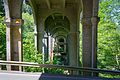 The Nehalem River Bridge conducts US 26 traffic over the Nehalem River and OR 103 in northwestern Oregon


References
- ^ a b "Fishhawk Falls Highway No. 103 Straightline Chart" (PDF). Oregon Department of Transportation. Retrieved February 10, 2014.
- ^ "Routes / State Highway Cross Reference Table". Oregon Department of Transportation. Retrieved February 10, 2014.
- ^ "History of State Highways in Oregon" (PDF). Oregon Department of Transportation. 2011. p. 521. Retrieved February 13, 2014.
- ^ "Descriptions of US and Oregon Routes" (PDF). Oregon Department of Transportation. July 2008. p. 14. Retrieved February 13, 2014.
External links
-
 Media related to
Oregon Route 103 at Wikimedia Commons
Media related to
Oregon Route 103 at Wikimedia Commons