Fillan | |
|---|---|
Village | |
 Fillan Location of the village  Fillan Fillan (Norway) | |
| Coordinates: 63°36′23″N 8°58′11″E / 63.6063°N 08.9696°E | |
| Country | Norway |
| Region | Central Norway |
| County | Trøndelag |
| District | Fosen |
| Municipality | Hitra |
| Area | |
| • Total | 1.08 km2 (0.42 sq mi) |
| Elevation | 35 m (115 ft) |
| Population (2018)
[1] | |
| • Total | 1,058 |
| • Density | 980/km2 (2,500/sq mi) |
| Time zone | UTC+01:00 ( CET) |
| • Summer ( DST) | UTC+02:00 ( CEST) |
| Post Code | 7240 Hitra |
Fillan is the administrative centre of Hitra municipality in Trøndelag county, Norway. The village is located on the northeastern side of the island of Hitra, about 5 kilometres (3.1 mi) south of the village of Ansnes. The island of Fjellværsøya lies about 3 kilometres (1.9 mi) to the northeast, across the Fillfjorden.
The 1.08-square-kilometre (270-acre) village has a population (2018) of 1,058 and a population density of 980 inhabitants per square kilometre (2,500/sq mi). [1]
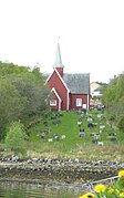
The village was the administrative centre of the old municipality of Fillan that existed from 1886 until 1964. Fillan Church is located in the village.
Media gallery
-
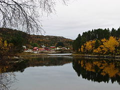
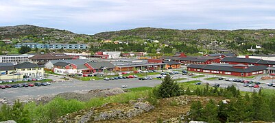 View of Fillan
 -
 View of Fillan
 -


References
- ^ a b c Statistisk sentralbyrå (1 January 2018). "Urban settlements. Population and area, by municipality".
- ^ "Fillan, Hitra (Trøndelag)". yr.no. Retrieved 2018-02-15.
|
| This Trøndelag location article is a stub. You can help Wikipedia by expanding it. |