No higher resolution available.
Xizang_prfc_map.png (721 × 404 pixels, file size: 63 KB, MIME type: image/png)
| This is a file from the
Wikimedia Commons. Information from its
description page there is shown below. Commons is a freely licensed media file repository. You can help. |
Summary
| Description |
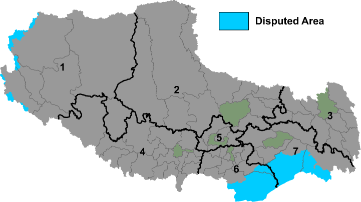
English: Map of prefectures of Tibet Autonomous Region |
| Source | Own work |
| Author | Maggern |
Licensing
| I, the copyright holder of this work, release this work into the
public domain. This applies worldwide. In some countries this may not be legally possible; if so: I grant anyone the right to use this work for any purpose, without any conditions, unless such conditions are required by law. |
File history
Click on a date/time to view the file as it appeared at that time.
| Date/Time | Thumbnail | Dimensions | User | Comment | |
|---|---|---|---|---|---|
| current | 08:56, 1 December 2018 |
| 721 × 404 (63 KB) | 希望探险家 | Correct the border line of Ngari Prefecture and Nagqu city. |
| 08:26, 14 April 2018 |
 | 721 × 404 (45 KB) | ASDFGH | update | |
| 03:16, 14 April 2018 |
 | 721 × 404 (44 KB) | ASDFGH | update | |
| 23:30, 14 March 2010 |
 | 721 × 404 (72 KB) | Maggern87 | Added more disputes in the west | |
| 17:20, 18 February 2010 |
 | 721 × 404 (71 KB) | Maggern87 | Added disputed area in west | |
| 08:12, 8 February 2010 |
 | 746 × 405 (69 KB) | Maggern87 | Fixed disputes (mostly in Nyingchi prefecture) | |
| 02:42, 23 December 2009 |
 | 921 × 500 (54 KB) | ASDFGHJ | Fix disputes | |
| 00:01, 1 December 2009 |
 | 921 × 500 (86 KB) | Maggern~commonswiki | {{Information |Description={{en|1=Map of prefectures of Xizang Autonomous Region (Tibet)}} |Source={{own}} |Author= Maggern |Date= |Permission= |other_versions= }} |
File usage
The following pages on the English Wikipedia use this file (pages on other projects are not listed):
Global file usage
The following other wikis use this file:
- Usage on be-tarask.wikipedia.org
- Usage on bn.wikipedia.org
- Usage on bo.wikipedia.org
- Usage on cs.wikipedia.org
- Usage on da.wikipedia.org
- Usage on es.wikipedia.org
- Usage on fa.wikipedia.org
- Usage on fi.wikipedia.org
- Usage on fr.wikipedia.org
- Usage on hr.wikipedia.org
- Usage on incubator.wikimedia.org
- Usage on it.wikipedia.org
- Usage on ja.wikipedia.org
- Usage on ky.wikipedia.org
- Usage on ms.wikipedia.org
- Senarai wilayah peringkat bahagian China
- Pengguna:Cinta Kirana
- Banggaidoi
- Alamdo
- Alhar
- Arza
- Asog
- Baga, Tibet
- Bagar, Daerah Lhari
- Baidi, Daerah Nagarzê
- Baima, Daerah Baxoi
- Baimai
- Baixoi
- Bamda
- Bamê
- Banag
- Bandar Banbar
- Bangkor
- Bangru (kampung)
- Bang'ai
- Bangxing
- Bêba
- Bongba
- Bumgyê
- Bungona’og
- Bünsum
- Caina
- Camco, Daerah Gêrzê
- Bandar Baqên
- Bayi, Daerah Nyingchi
- Bilung
- Bandar Biru
- Bolo, Daerah Gonjo
View more global usage of this file.