
Size of this preview:
800 × 475 pixels. Other resolutions:
320 × 190 pixels |
640 × 380 pixels |
1,024 × 608 pixels |
1,280 × 761 pixels |
2,560 × 1,521 pixels |
6,693 × 3,977 pixels.
Original file (6,693 × 3,977 pixels, file size: 761 KB, MIME type: image/png)
| This is a file from the
Wikimedia Commons. Information from its
description page there is shown below. Commons is a freely licensed media file repository. You can help. |
Summary
| Description |
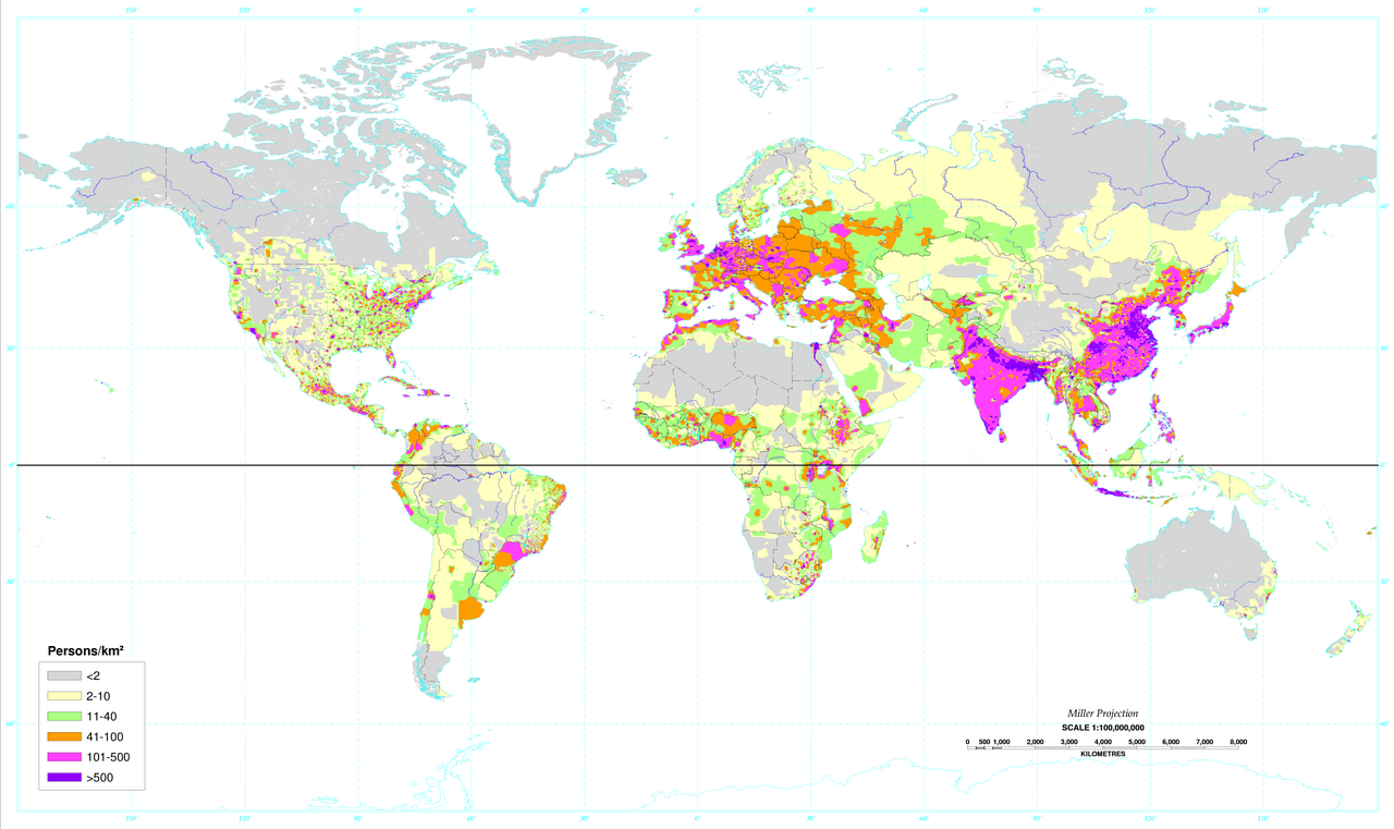
English: World map of the population density in 1994. (A more recent population density map can be found at
http://sedac.ciesin.columbia.edu/gpw/) This map clearly shows how the vast majority of the human population lives significantly north of the equator. |
| Date | Data from 1994. Image made in 2000. (Equator added on 2016-03-13.) |
| Source |
 World population density 1994.png (same map, but no black line on the equator shown) |
| Author | /info/en/?search=United_States_Department_of_Agriculture |

|
This map image could be re-created using
vector graphics as an
SVG file. This has several advantages; see
Commons:Media for cleanup for more information. If an SVG form of this image is available, please upload it and afterwards replace this template with
{{
vector version available|new image name}}
.
It is recommended to name the SVG file “World population density 1994 - with equator.svg”—then the template Vector version available (or Vva) does not need the new image name parameter. |
Licensing
This work is in the
public domain in the United States because it is a
work prepared by an officer or employee of the United States Government as part of that person’s official duties under the terms of
Title 17, Chapter 1, Section 105 of the
US Code.
Note: This only applies to original works of the Federal Government and not to the work of any individual
U.S. state,
territory, commonwealth, county, municipality, or any other subdivision. This template also does not apply to postage stamp designs published by the
United States Postal Service
since 1978. (See §
313.6(C)(1) of Compendium of U.S. Copyright Office Practices). It also does not apply to certain US coins; see
The US Mint Terms of Use.
|
 | |
| This file has been identified as being free of known restrictions under copyright law, including all related and neighboring rights. | ||
File history
Click on a date/time to view the file as it appeared at that time.
| Date/Time | Thumbnail | Dimensions | User | Comment | |
|---|---|---|---|---|---|
| current | 21:22, 16 June 2023 |
| 6,693 × 3,977 (761 KB) | Getsnoopy | Fixed a unit formatting issue. |
| 02:35, 4 May 2020 |
 | 6,693 × 3,977 (954 KB) | XyKyWyKy | color adjustment for better contrast | |
| 12:24, 13 March 2016 |
 | 6,693 × 3,977 (1.13 MB) | Invent2HelpAll | User created page with UploadWizard |
File usage
The following pages on the English Wikipedia use this file (pages on other projects are not listed):
Global file usage
The following other wikis use this file:
- Usage on af.wikipedia.org
- Usage on ar.wikipedia.org
- Usage on ast.wikipedia.org
- Usage on ca.wikipedia.org
- Usage on fr.wikipedia.org
- Usage on mt.wikipedia.org
- Usage on ta.wikipedia.org