
Original file (SVG file, nominally 1,238 × 939 pixels, file size: 4.02 MB)
| This is a file from the
Wikimedia Commons. Information from its
description page there is shown below. Commons is a freely licensed media file repository. You can help. |
Summary
| Description |
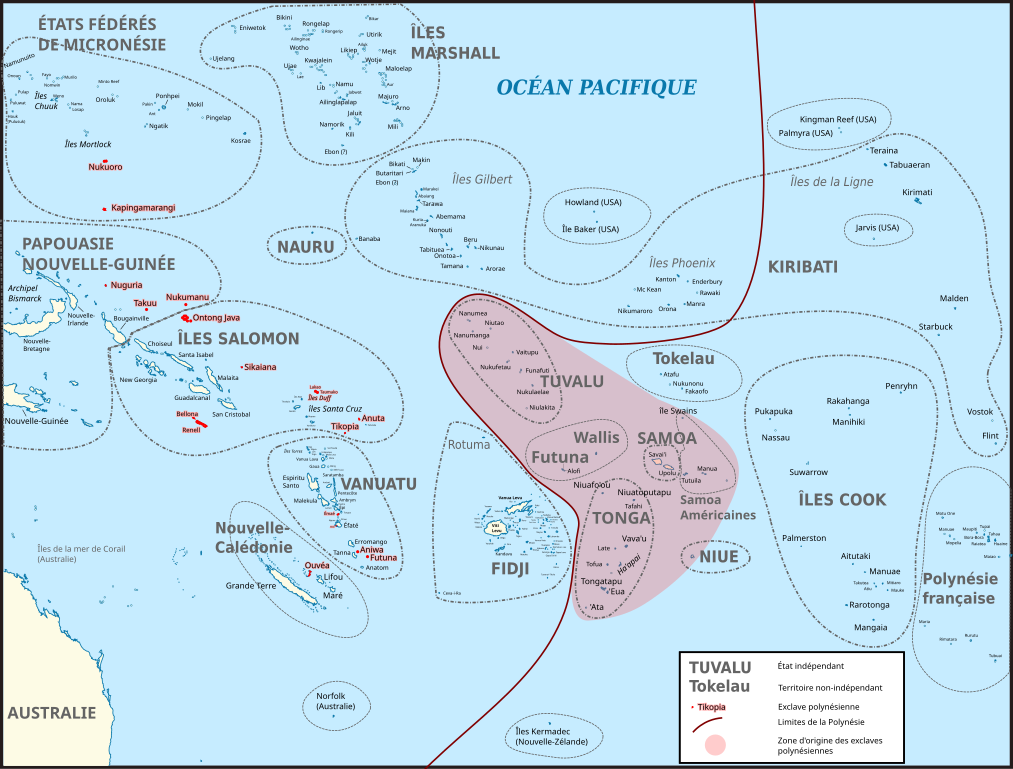
Français : Carte du Pacifique montrant la Polynésie occidentale et les différentes exclaves polynésiennes (en rouge). La zone en rouge clair correspond à la zone originelle de peuplement de Polynésie, d'où sont parties les populations qui habitent les exclaves polynésiennes. Les traits entourant les différents territoires ne sont pas les frontières maritimes actuelles, simplement un repère.
Carte d’origine : File:BLANK in Oceania (small islands magnified) (-mini map -rivers).svg Sources pour les noms des îles : Fidji : File:FijiOMCmap.png Nouvelle-Calédonie et Vanuatu :
Îles Salomon :
Tonga: FIle:Tonga.jpg Micronésie : File:Micronesia,_administrative_divisions_with_island_names_-_colored_-_fr.svg Îles Marshall: Kiribati :
Polynésie française : File:French_Polynesia_relief_map.svg Liste des exclaves polynésiennes : https://fr.wikipedia.org/wiki/Exclaves_polyn%C3%A9siennes
English: Map of Oceania showing Polynesian outliers. The red zone is the original Polynesian homeland, from where Polynesian seafarers went to the various Polynesian outliers. The lines around countries and territories are not the actual maritime borders.
Sources for this map : Original map : File:BLANK in Oceania (small islands magnified) (-mini map -rivers).svg Island names : Fidji : File:FijiOMCmap.png New Caledonia and Vanuatu
Solomon Islands :
Tonga: FIle:Tonga.jpg Micronesia: File:Micronesia,_administrative_divisions_with_island_names_-_colored_-_fr.svg Marshall islands: Kiribati :
French Polynesia : File:French_Polynesia_relief_map.svg List of Polynesian Outliers : https://fr.wikipedia.org/wiki/Exclaves_polyn%C3%A9siennes |
| Date | |
| Source | Own work |
| Author | Skimel |
_(-mini_map_-rivers).svg)
.png)
Licensing
- You are free:
- to share – to copy, distribute and transmit the work
- to remix – to adapt the work
- Under the following conditions:
- attribution – You must give appropriate credit, provide a link to the license, and indicate if changes were made. You may do so in any reasonable manner, but not in any way that suggests the licensor endorses you or your use.
- share alike – If you remix, transform, or build upon the material, you must distribute your contributions under the same or compatible license as the original.
File history
Click on a date/time to view the file as it appeared at that time.
| Date/Time | Thumbnail | Dimensions | User | Comment | |
|---|---|---|---|---|---|
| current | 13:44, 12 November 2016 |
| 1,238 × 939 (4.02 MB) | Skimel | Changed the fonts to DejaVu Sans condensed, resized the map, changed the shape of some country borders to fit the text better. |
| 11:50, 12 November 2016 |
 | 2,476 × 1,885 (3.99 MB) | Skimel | Fixed the black box in the upper left corner, resized the map so that one can zoom in more (but apparently caused other black rectangles...) | |
| 13:22, 11 November 2016 |
 | 617 × 466 (3.98 MB) | Skimel | User created page with UploadWizard |
File usage
Global file usage
The following other wikis use this file:
- Usage on ca.wikipedia.org
- Usage on es.wikipedia.org
- Usage on fr.wikipedia.org
- Usage on it.wikipedia.org
- Usage on ja.wikipedia.org
- Usage on ko.wikipedia.org
- Usage on pt.wikipedia.org