
Size of this preview:
800 × 600 pixels. Other resolutions:
320 × 240 pixels |
640 × 480 pixels |
1,024 × 768 pixels |
1,280 × 960 pixels |
2,560 × 1,920 pixels |
2,816 × 2,112 pixels.
Original file (2,816 × 2,112 pixels, file size: 2.13 MB, MIME type: image/jpeg)
| This is a file from the
Wikimedia Commons. Information from its
description page there is shown below. Commons is a freely licensed media file repository. You can help. |
| Camera location |
| View this and other nearby images on: OpenStreetMap |
|
|---|
| Description |
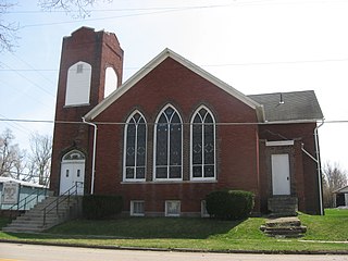
English: West Mansfield
Friends Church, located on the southwestern corner of Center (County Road 8) and Dean Streets in
West Mansfield,
Ohio,
United States. It was built in 1912. |
||
| Date | Taken on 5 April 2010 | ||
| Source | Own work | ||
| Author | Nyttend | ||
| Permission ( Reusing this file) |
|
||
| Other versions | None |
File history
Click on a date/time to view the file as it appeared at that time.
| Date/Time | Thumbnail | Dimensions | User | Comment | |
|---|---|---|---|---|---|
| current | 00:03, 6 April 2010 |
| 2,816 × 2,112 (2.13 MB) | Nyttend | {{Location|40|24|6|N|83|32|48|W}} {{Information |Description={{en|West Mansfield {{w|Evangelical Friends International|Friends Church}}, located on the southwestern corner of Center (County Road 8) and Dean Streets in {{w|West Mansfield, Ohio|West Mansfie |
File usage
The following pages on the English Wikipedia use this file (pages on other projects are not listed):
Global file usage
The following other wikis use this file:
- Usage on en.wikiquote.org
- Usage on he.wikipedia.org