No higher resolution available.
West_Bank_Bantustans_proposed_in_the_Trump_Peace_Plan_Map_(cropped).jpg (222 × 530 pixels, file size: 132 KB, MIME type: image/jpeg)
| This is a file from the
Wikimedia Commons. Information from its
description page there is shown below. Commons is a freely licensed media file repository. You can help. |
Summary
| Description |
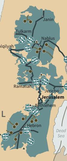
English: Map of the Trump peace plan |
| Date | |
| Source | White House publication - https://www.whitehouse.gov/wp-content/uploads/2020/01/Peace-to-Prosperity-0120.pdf |
| Author | US Federal Government |
| Other versions |

.jpg)
Licensing
This file is a work of an employee of the
Executive Office of the President of the United States, taken or made as part of that person's official duties. As a
work of the
U.S. federal government, it is in the
public domain.
|
 |
File history
Click on a date/time to view the file as it appeared at that time.
| Date/Time | Thumbnail | Dimensions | User | Comment | |
|---|---|---|---|---|---|
| current | 09:14, 12 November 2020 |
| 222 × 530 (132 KB) | Onceinawhile | File:Trump Peace Plan Map.jpg cropped 82 % horizontally, 67 % vertically using CropTool with precise mode. |
File usage
The following pages on the English Wikipedia use this file (pages on other projects are not listed):
Global file usage
The following other wikis use this file:
- Usage on ar.wikipedia.org
- Usage on el.wikipedia.org
- Usage on fr.wikipedia.org
- Usage on id.wikipedia.org
- Usage on pt.wikipedia.org
- Usage on sr.wikipedia.org
.jpg)