
Size of this preview:
800 × 575 pixels. Other resolutions:
320 × 230 pixels |
640 × 460 pixels |
1,024 × 737 pixels |
1,280 × 921 pixels |
2,490 × 1,791 pixels.
Original file (2,490 × 1,791 pixels, file size: 1.05 MB, MIME type: image/jpeg)
| This is a file from the
Wikimedia Commons. Information from its
description page there is shown below. Commons is a freely licensed media file repository. You can help. |
Summary
| Description |
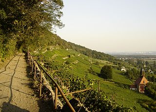
Deutsch: Sächsischer Weinwanderweg bei Pillnitz, Dresden
English: Trail through the saxon viticultural region near Pillnitz, Dresden |
| Date | |
| Source | Own work |
| Author | Geo-Loge |
| Permission ( Reusing this file) |
Panoramafreiheit |
| Object location |
| View this and other nearby images on: OpenStreetMap |
|
|---|
| Camera location |
| View this and other nearby images on: OpenStreetMap |
|
|---|
Licensing
I, the copyright holder of this work, hereby publish it under the following licenses:

|
Permission is granted to copy, distribute and/or modify this document under the terms of the GNU Free Documentation License, Version 1.2 or any later version published by the Free Software Foundation; with no Invariant Sections, no Front-Cover Texts, and no Back-Cover Texts. A copy of the license is included in the section entitled GNU Free Documentation License. |
| This file is licensed under the Creative Commons Attribution-Share Alike 3.0 Unported license. | ||
| ||
| This licensing tag was added to this file as part of the GFDL licensing update. |
This file is licensed under the
Creative Commons Attribution-Share Alike
2.5 Generic,
2.0 Generic and
1.0 Generic license.
- You are free:
- to share – to copy, distribute and transmit the work
- to remix – to adapt the work
- Under the following conditions:
- attribution – You must give appropriate credit, provide a link to the license, and indicate if changes were made. You may do so in any reasonable manner, but not in any way that suggests the licensor endorses you or your use.
- share alike – If you remix, transform, or build upon the material, you must distribute your contributions under the same or compatible license as the original.
You may select the license of your choice.
File history
Click on a date/time to view the file as it appeared at that time.
| Date/Time | Thumbnail | Dimensions | User | Comment | |
|---|---|---|---|---|---|
| current | 14:45, 26 September 2006 |
| 2,490 × 1,791 (1.05 MB) | Geo-Loge~commonswiki | {{Information |Description=Trail through the saxon viticultural region near Pillnitz (Sächsischer Weinwanderweg bei Pillnitz) |Source=own work |Date=25 September 2006 |Author= Geo-Loge |Permission=Panoramafreiheit }} == Licensing == {{se |
File usage
The following pages on the English Wikipedia use this file (pages on other projects are not listed):
Global file usage
The following other wikis use this file:
- Usage on cs.wikipedia.org
- Usage on de.wikipedia.org
- Sächsische Weinstraße
- Sachsen (Weinanbaugebiet)
- Sächsischer Weinwanderweg
- Benutzer:Paulae/Archiv 2009
- Liste der Kulturdenkmale in Pillnitz
- Benutzer:Kleeblatt187/SN-DD-eingeschränkt
- Benutzer:Kleeblatt187/SN-DD-nur-Innerortsstraßen
- Benutzer:Z thomas/DE-SN-Straßen-Dresden
- Liste sächsischer Weinberge und Weingüter
- Usage on de.wikivoyage.org
- Usage on mk.wikipedia.org
- Usage on nl.wikipedia.org
- Usage on pl.wikipedia.org
- Usage on www.wikidata.org