
Size of this preview:
800 × 533 pixels. Other resolutions:
320 × 213 pixels |
640 × 427 pixels |
1,024 × 683 pixels |
1,280 × 853 pixels |
2,560 × 1,707 pixels |
3,456 × 2,304 pixels.
Original file (3,456 × 2,304 pixels, file size: 6.26 MB, MIME type: image/jpeg)
| This is a file from the
Wikimedia Commons. Information from its
description page there is shown below. Commons is a freely licensed media file repository. You can help. |
Summary
| Description |
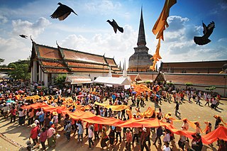
English: A procession of Buddhists bearing a long cloth to wrap around the stupa (in the far back) during Hae Pha Khuen That Festival at Wat Phra Maha That Woramahawihan,
Nakhon Si Thammarat Province, southern
Thailand. The temple is currently on the Tentative List of UNESCO World Heritage Sites.
Русский: Шествие буддистов и
храм Пхра Махатхат во время Фестиваля Хе Пха Кхын Тхат.
Провинция Накхонситхаммарат, Таиланд
ไทย: ขบวนพุทธศาสนิกชนกำลังแห่ผ้าผืนยาวขึ้นไปห่มรอบองค์พระบรมธาตุเจดีย์ของ
วัดพระมหาธาตุวรมหาวิหาร
จังหวัดนครศรีธรรมราช ตาม
ประเพณีแห่ผ้าขึ้นธาตุ ปัจจุบันวัดแห่งนี้เป็นหนึ่งในสถานที่ที่ได้รับการขึ้นบัญชีรายชื่อเบื้องต้นเพื่อพิจารณาเป็นแหล่งมรดกโลกในอนาคต
Українська: Хода будистів і храм Пхра Махатхат під час Фестивалю Хе Пха Кхин Тхат. Провінція Накхонсітхаммарат, Таїланд
Deutsch: Eine Prozession von Buddhisten mit einem langen Schal, der während des Hae Pha Khuen That-Festivals um die Stupa im Hintergrund geschlungen wird. Wat Phra Maha That Woramahawihan, Provinz Nakhon Si Thammarat im Süden Thailands.
|
||
| Date | |||
| Source | Own work | ||
| Author | KOSIN SUKHUM |
| Camera location | | View this and other nearby images on: OpenStreetMap |
|
|---|
Licensing
I, the copyright holder of this work, hereby publish it under the following license:
This file is licensed under the
Creative Commons
Attribution-Share Alike 4.0 International license.
- You are free:
- to share – to copy, distribute and transmit the work
- to remix – to adapt the work
- Under the following conditions:
- attribution – You must give appropriate credit, provide a link to the license, and indicate if changes were made. You may do so in any reasonable manner, but not in any way that suggests the licensor endorses you or your use.
- share alike – If you remix, transform, or build upon the material, you must distribute your contributions under the same or compatible license as the original.

|
This image was awarded with the 9th prize worldwide in
Wiki Loves Monuments 2015 Other languages:
|

|
This image was uploaded as part of
Wiki Loves Monuments 2015.
|
 |
File history
Click on a date/time to view the file as it appeared at that time.
| Date/Time | Thumbnail | Dimensions | User | Comment | |
|---|---|---|---|---|---|
| current | 19:37, 22 September 2015 |
| 3,456 × 2,304 (6.26 MB) | KOSIN SUKHUM | User created page with UploadWizard |
File usage
The following pages on the English Wikipedia use this file (pages on other projects are not listed):
Global file usage
The following other wikis use this file:
- Usage on bcl.wikipedia.org
- Usage on ca.wikipedia.org
- Usage on de.wikipedia.org
- Usage on de.wikivoyage.org
- Usage on en.wikivoyage.org
- Usage on fa.wikipedia.org
- Usage on fr.wikinews.org
- Usage on he.wikipedia.org
- Usage on hy.wikipedia.org
- Usage on incubator.wikimedia.org
- Usage on io.wikipedia.org
- Usage on ka.wikipedia.org
- Usage on ml.wikipedia.org
- Usage on mn.wikipedia.org
- Usage on ms.wikipedia.org
- Usage on my.wikipedia.org
- Usage on ne.wikipedia.org
- Usage on pt.wikipedia.org
- Usage on th.wikipedia.org
- Usage on zh.wikipedia.org