Size of this preview:
449 × 599 pixels. Other resolutions:
180 × 240 pixels |
533 × 711 pixels.
Original file (533 × 711 pixels, file size: 142 KB, MIME type: image/jpeg)
| This is a file from the
Wikimedia Commons. Information from its
description page there is shown below. Commons is a freely licensed media file repository. You can help. |
Summary
| Description |
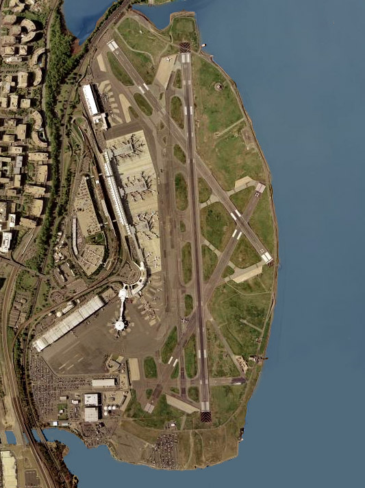
English: Aerial photo of
Ronald Reagan Washington National Airport in Arlington County, Virginia, United States. |
| Date | Taken on 26 April 2002 |
| Source | USGS The National Map, via MSR Maps: Image, Interactive map |
| Author | United States Geological Survey (USGS) |
| Permission ( Reusing this file) |
Public domain |
Licensing
This image is in the
public domain in the United States because it only contains materials that originally came from the
United States Geological Survey, an agency of the
United States Department of the Interior. For more information, see
the official USGS copyright policy.
|
File history
Click on a date/time to view the file as it appeared at that time.
| Date/Time | Thumbnail | Dimensions | User | Comment | |
|---|---|---|---|---|---|
| current | 08:37, 4 January 2007 |
| 533 × 711 (142 KB) | Estoymuybueno | Original image source: USGS satellite image of Ronald Reagan Washington National Airport. Fuente original: foto del satélite de USGS del aeropuerto nacional de Washington Ronald Reagan From/de: http://en.wikipedia.org/wiki/Image:Washington_national_ai |
File usage
The following pages on the English Wikipedia use this file (pages on other projects are not listed):
Global file usage
The following other wikis use this file:
- Usage on af.wikipedia.org
- Usage on ar.wikipedia.org
- Usage on arz.wikipedia.org
- Usage on ast.wikipedia.org
- Usage on ca.wikipedia.org
- Usage on ceb.wikipedia.org
- Usage on cs.wikipedia.org
- Usage on de.wikipedia.org
- Usage on de.wikivoyage.org
- Usage on en.wikivoyage.org
- Usage on es.wikipedia.org
- Usage on eu.wikipedia.org
- Usage on fi.wikipedia.org
- Usage on he.wikipedia.org
- Usage on hu.wikipedia.org
- Usage on id.wikipedia.org
- Usage on it.wikipedia.org
- Usage on ja.wikipedia.org
- Usage on ko.wikipedia.org
- Usage on nl.wikipedia.org
- Usage on no.wikipedia.org
- Usage on pl.wikipedia.org
- Usage on pt.wikipedia.org
- Voo Eastern Air Lines 537
- Portal:Aviação/Artigo bom
- Aeroporto Nacional Ronald Reagan de Washington
- Portal:Aviação/Datas selecionadas/Novembro
- Portal:Aviação/Datas selecionadas/19 de novembro
- Incidente de OVNI em Washington de 1952
- Wikipédia:Artigos bons/arquivo/Incidente de OVNI em Washington de 1952
- Portal:Aviação/Artigo bom/Arquivo/Incidente de OVNI em Washington de 1952
- Usage on ru.wikipedia.org
- Usage on sco.wikipedia.org
- Usage on simple.wikipedia.org
- Usage on sv.wikipedia.org
- Usage on th.wikipedia.org
- Usage on uk.wikipedia.org
- Usage on ur.wikipedia.org
- Usage on vi.wikipedia.org
- Usage on www.wikidata.org
- Usage on zh-yue.wikipedia.org
- Usage on zh.wikipedia.org