
Size of this preview:
800 × 533 pixels. Other resolutions:
320 × 213 pixels |
640 × 427 pixels |
1,024 × 683 pixels |
1,280 × 853 pixels |
2,560 × 1,707 pixels |
5,184 × 3,456 pixels.
Original file (5,184 × 3,456 pixels, file size: 4.54 MB, MIME type: image/jpeg)
| This is a file from the
Wikimedia Commons. Information from its
description page there is shown below. Commons is a freely licensed media file repository. You can help. |
| Object location |
| View this and other nearby images on: OpenStreetMap |
|
|---|
Summary
| Description |
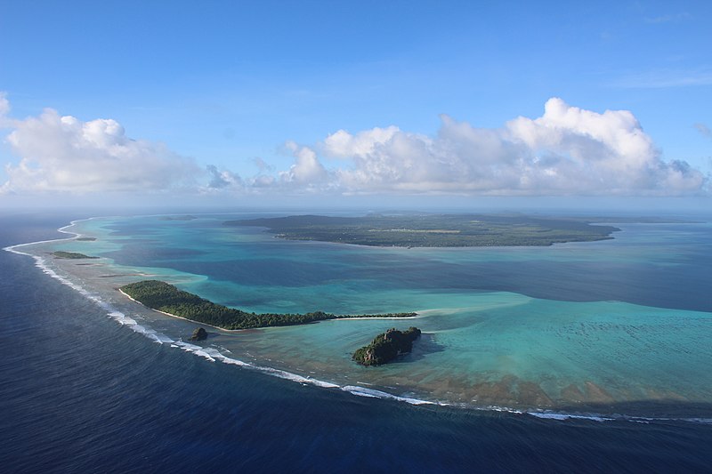
Français : Observer Wallis du ciel change radicalement la perspective de l'île. On y voit le lagon dans toute sa splendeur, la barrière de corail est nettement définie, et les différents îlots (dans l'ordre, de droite à gauche : Nukufotu, Nukula'ela'e (tout petit), Nukuloa puis Nukuteatea et enfin Nukutapu). Avec un peu de chance, on peut même voir quelques raies qui sautent, de requins qui nagent, ou quelques fois, des baleines perdues dans le lagon !
English: Aerial photograph of Wallis island (South Pacific). The North of the lagoon and the coral reef is visible with the islets Nukufotu, Nukula'ela'e (very small), Nukuloa then Nukuteatea and finally Nukutapu. The mainland (Wallis island) is visible in the background. |
| Date | |
| Source | Own work |
| Author | Anna Vinet |
| Other versions |
.jpg)

.jpg)
Licensing
I, the copyright holder of this work, hereby publish it under the following license:
This file is licensed under the
Creative Commons
Attribution-Share Alike 4.0 International license.
- You are free:
- to share – to copy, distribute and transmit the work
- to remix – to adapt the work
- Under the following conditions:
- attribution – You must give appropriate credit, provide a link to the license, and indicate if changes were made. You may do so in any reasonable manner, but not in any way that suggests the licensor endorses you or your use.
- share alike – If you remix, transform, or build upon the material, you must distribute your contributions under the same or compatible license as the original.
|
|
This picture has been imported as part of the
Photographiez les Outre-Mer contest, organized by
Wikimédia France, the
French Development Agency and the
Ministry of Overseas France.
|

|
This image has been assessed under the valued image criteria and is considered the most valued image on Commons within the scope: Aerial photographs of Wallis lagoon seen from the North. You can see its nomination here. |
File history
Click on a date/time to view the file as it appeared at that time.
| Date/Time | Thumbnail | Dimensions | User | Comment | |
|---|---|---|---|---|---|
| current | 10:37, 11 August 2018 |
| 5,184 × 3,456 (4.54 MB) | Vinean10 | User created page with UploadWizard |
File usage
The following pages on the English Wikipedia use this file (pages on other projects are not listed):
Global file usage
The following other wikis use this file:
- Usage on ceb.wikipedia.org
- Usage on fr.wikipedia.org
- Usage on hi.wikipedia.org
- Usage on id.wikipedia.org
- Usage on incubator.wikimedia.org
- Usage on is.wikipedia.org
- Usage on it.wikipedia.org
- Usage on rn.wikipedia.org
- Usage on to.wikipedia.org
- Usage on www.wikidata.org