Size of this preview:
800 × 556 pixels. Other resolutions:
320 × 222 pixels |
640 × 444 pixels |
1,024 × 711 pixels |
1,280 × 889 pixels |
2,560 × 1,778 pixels |
5,472 × 3,800 pixels.
Original file (5,472 × 3,800 pixels, file size: 12.98 MB, MIME type: image/jpeg)
| This is a file from the
Wikimedia Commons. Information from its
description page there is shown below. Commons is a freely licensed media file repository. You can help. |
Summary
| Description |
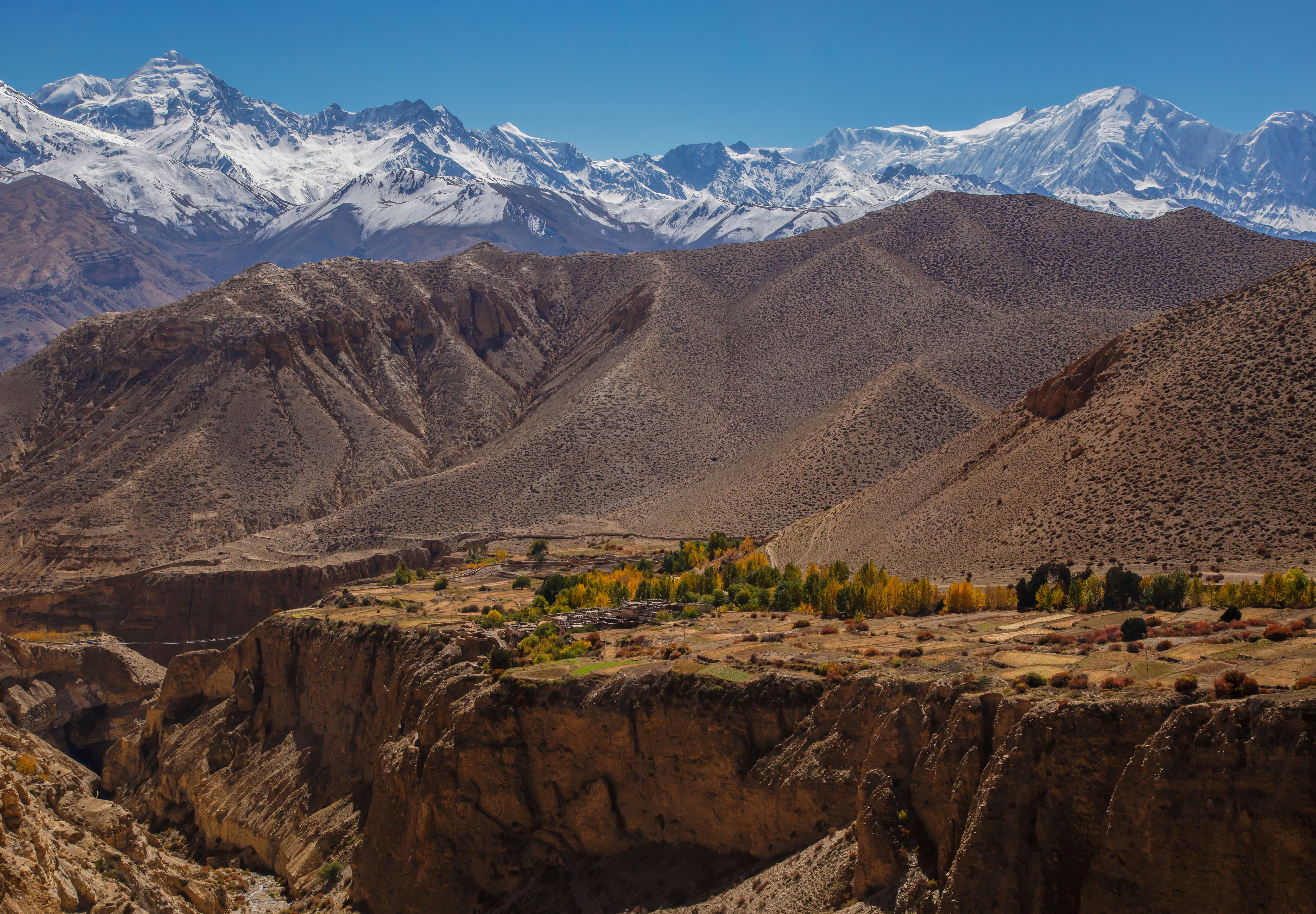
English: Majestic view on the village of Gyakar surrounded by a poplar grove and the summits of the Damodar Himal, the Purkung Himal and the Annapurnas. We were so lucky with the weather, having such a visibility all day long is not that common even in October after the monsoon.
Notice the suspended bridge over the deep canyon on the left. |
| Date | Taken on 23 October 2014, 11:24:53 |
| Source |
This file was derived from:
View on Gyakar.jpg |
| Author |
|
| Other versions |
|

.jpg)
| Camera location |
| View this and other nearby images on: OpenStreetMap |
|
|---|
.jpg¶ms=028.943808_N_0083.805482_E_globe:Earth_type:camera__&language=en)
| This is a
retouched picture, which means that it has been digitally altered from its original version. Modifications: Dust stop removed, noise reduced. Modifications made by
UnpetitproleX.
|
| This is a
retouched picture, which means that it has been digitally altered from its original version. Modifications: Added a little bit more sky. Modifications made by
Aristeas.
|
Assessment
|
Licensing
I, the copyright holder of this work, hereby publish it under the following license:
This file is licensed under the
Creative Commons
Attribution 3.0 Unported license.
- You are free:
- to share – to copy, distribute and transmit the work
- to remix – to adapt the work
- Under the following conditions:
- attribution – You must give appropriate credit, provide a link to the license, and indicate if changes were made. You may do so in any reasonable manner, but not in any way that suggests the licensor endorses you or your use.
File history
Click on a date/time to view the file as it appeared at that time.
| Date/Time | Thumbnail | Dimensions | User | Comment | |
|---|---|---|---|---|---|
| current | 16:52, 3 June 2022 |
| 5,472 × 3,800 (12.98 MB) | Aristeas | =={{int:filedesc}}== {{Information |description={{en|1=Majestic view on the village of Gyakar surrounded by a poplar grove and the summits of the Damodar Himal, the Purkung Himal and the Annapurnas. We were so lucky with the weather, having such a visibility all day long is not that common even in October after the monsoon. Notice the suspended bridge over the deep canyon on the left.}} |date={{Taken on|2014-10-23 11:24:53|location=Nepal}} |source={{Derived from|File:View on Gyakar.jpg}} |aut... |
File usage
The following pages on the English Wikipedia use this file (pages on other projects are not listed):
Global file usage
The following other wikis use this file:
- Usage on fr.wikipedia.org
- Usage on ne.wikipedia.org
.jpg)