
Size of this preview:
800 × 600 pixels. Other resolutions:
320 × 240 pixels |
640 × 480 pixels |
1,024 × 768 pixels.
Original file (1,024 × 768 pixels, file size: 244 KB, MIME type: image/jpeg)
| This is a file from the
Wikimedia Commons. Information from its
description page there is shown below. Commons is a freely licensed media file repository. You can help. |
Summary
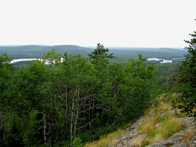
| Description | View from near the top of Eagle Mountain, the highest point in Minnesota. Visible are the surrounding Misquah Hills and the North Branch of the Cascade River. Eagle Lake can be seen at the right of the photo, and Shrike Lake at the left. Photo taken by Douglas Kaye in 2006, from the last clear view near the end of the trail to the peak. |
| Date | 5 April 2007 (original upload date) |
| Source | No machine-readable source provided. Own work assumed (based on copyright claims). |
| Author | No machine-readable author provided. MisterSquirrel~commonswiki assumed (based on copyright claims). |
Licensing
| I, the copyright holder of this work, release this work into the
public domain. This applies worldwide. In some countries this may not be legally possible; if so: I grant anyone the right to use this work for any purpose, without any conditions, unless such conditions are required by law. |
File history
Click on a date/time to view the file as it appeared at that time.
| Date/Time | Thumbnail | Dimensions | User | Comment | |
|---|---|---|---|---|---|
| current | 12:18, 5 April 2007 |
| 1,024 × 768 (244 KB) | MisterSquirrel~commonswiki | View from near the top of Eagle Mountain, the highest point in Minnesota. Visible are the surrounding Misquah Hills and the North Branch of the Cascade River. Eagle Lake can be seen at the right of the photo, and Shrike Lake at the left. Photo taken by Do |
File usage
The following pages on the English Wikipedia use this file (pages on other projects are not listed):
Global file usage
The following other wikis use this file:
- Usage on ca.wikipedia.org
- Usage on ceb.wikipedia.org
- Usage on de.wikipedia.org
- Usage on es.wikipedia.org
- Usage on fa.wikipedia.org
- Usage on fr.wikipedia.org
- Usage on he.wikipedia.org
- Usage on it.wikipedia.org
- Usage on nl.wikipedia.org
- Usage on ru.wikipedia.org
- Usage on www.wikidata.org
- Usage on zh.wikipedia.org